Map size in jpg-format: 20.8715MiB
Click to open in high resolution (open in new tab).
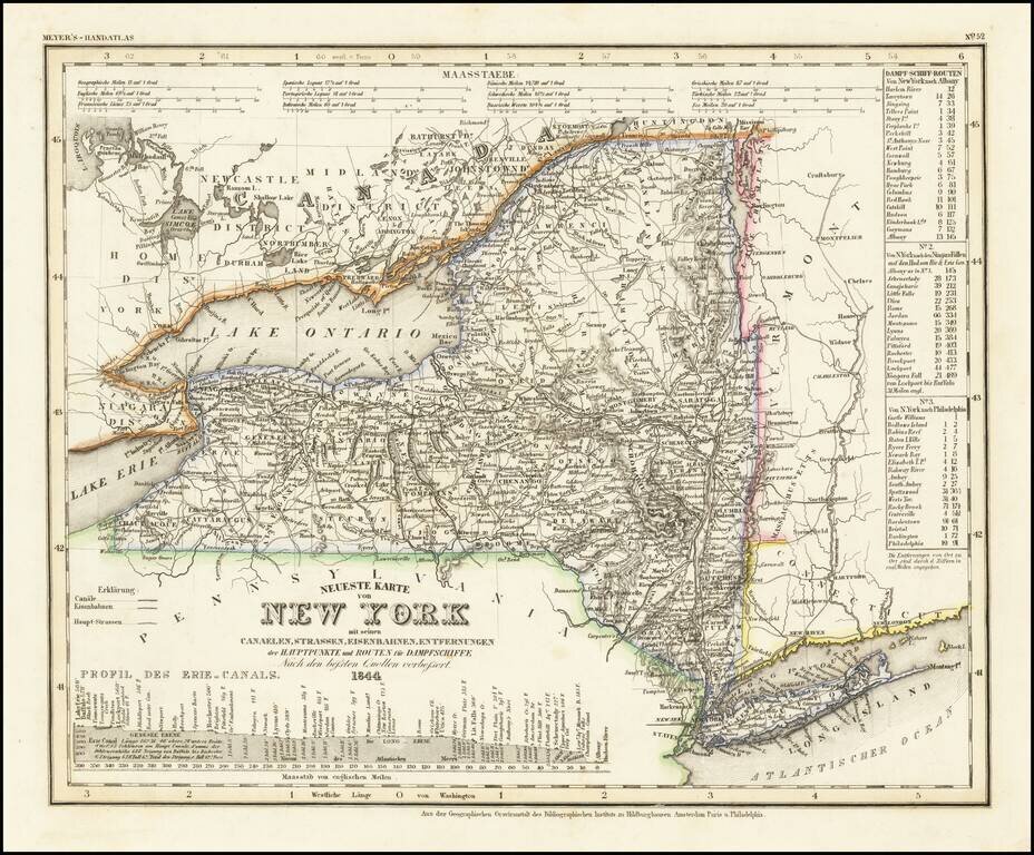
One of the First Maps of New York State Printed in Germany
Detailed map of New York State, published during a period of great German interest in America and a boom in German emigration to the United States.
The map shows the routes, railroads, and distances in the state, though it also locates various other features including rivers, canals, and more. The names and outlines of the counties at the time are shown. The adjoining states of Pennsylvania, Vermont, and Connecticut, as well as part of Canada, are all shown.
The map includes an inset showing the profile of the Erie Canal. The many locks, rivers, and cities along this all-important waterway are shown. An inlay to the main map provides the distances to various towns along the New York to Albany, Niagara Falls, and Philadelphia routes. Conversions to other measures of distance are included.
While this work is often referred to as the "German Mitchell," referring the American map maker S. A. Mitchell to whom Tanner sold his plates, the work predates this latter's sale and appears to be a collaborative effort.
Of great interest is the suggestion that the work was published in Hildburghausen, Amsterdam, Philadelphia and Paris, although no evidence of a French edition is known to us. The engraving quality of this fine item surpasses its American counterpart.
Joseph Meyer (1796-1856) was a German publisher who released Meyers Konversations-Lexikon, a German-language encyclopedia in print from 1839 to 1984. Meyer was born in Gotha and educated as a merchant in Frankfurt, an important city in the book trade. He traveled in London in 1816 and was back in German in 1820, where he began to invest in textiles and railways. He opened his publishing operation, Bibliographisches Institut, in 1826. His publications each had a serial number, a new innovation at the time. He was best known for his atlases and the Meyers Universum (1833-1861), which featured steel-engravings of the world. The Universum stretched to 17 volumes in 12 languages and was subscribed to by 80,000 people all over Europe. Thanks to his publishing success, Meyer moved the Institut from Gotha to Hildburghausen in 1828. Meyer died in the latter city in 1856.
If you are a student, write to us in telegram: @antiquemaps and indicate what material you need and for what work you need a map in high detail. We are ready to provide material on special terms. For students only!

![[Site of A Presidential Assassination] Plan of the Pan American Exposition to be held at Buffalo, New York (May 1 - Nov. 1, 1901)](/map/small/69181.jpg)