logo

1854. Morse's Map of Illinois

  • Morse's Map of Illinois
  • Morse's Map of Illinois

Map size in jpg-format: 77.6429MiB

Download "Morse's Map of Illinois", in high resolution.

Morse's Map of Illinois information:

Year of creation: 
Resolution size (pixels): 
 13699x18407 px
Disk Size: 
 77.6429MiB
Number of pages: 
 2
Place: 
 New York
Author: 

Print information. Print size (Width x height in inches):
Printing at 72 dpi 
  190.26 х 255.65
Printing at 150 dpi 
 91.33 х 122.71
Printing at 300 dpi 
 45.66 х 61.36

An example of detailing the file of this map of in a printable high-resolution:

Click to open in high resolution (open in new tab).
Attention! this is just the central piece (central area 960x960 px) of the map file!
This is an example, so that you can see and study the level of detail of a given map. The entire Map will be fully available after payment!

Morse's Map of Illinois

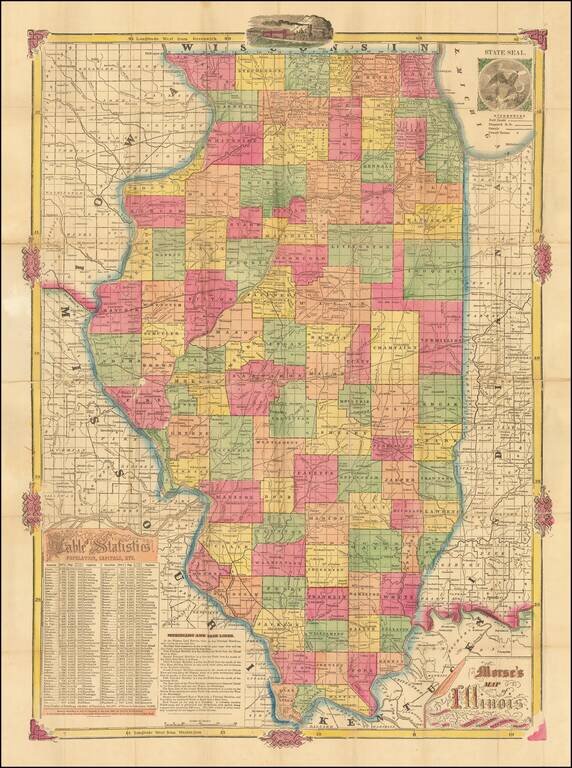
Rare early map of Illinois, published by Rufus Blanchard prior to his move to Chicago.

Includes a 'Table of Statistics' and 'Meridians and Baselines' in the lower left corner.

The map is printed using the cerographic printed method, an American invention attributed to the Morse family.


Special conditions for students!

If you are a student, write to us in telegram: @antiquemaps and indicate what material you need and for what work you need a map in high detail. We are ready to provide material on special terms. For students only!

Item information:

Year of creation:
Size:
13699x18407 px
Disk:
77.6429MiB
Number of pages:
2
Place:
New York
Author:
Rufus Blanchard.
$14.99

Related item