Map size in jpg-format: 731108B
Click to open in high resolution (open in new tab).
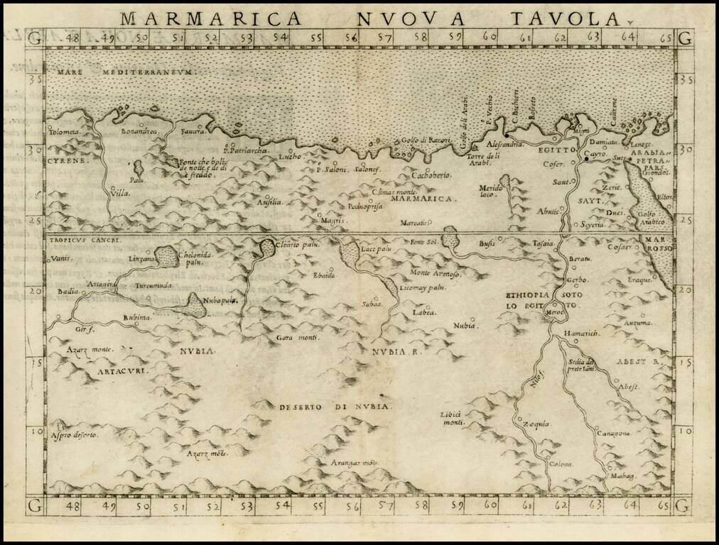
Fine early map of part of North Africa, centered on the Nubia Desert and showing Egypt, the Nile, etc.
From Ruscell's edition of Ptolemy, Ptolemeo. La Geografia…, first published in Venice in 1561.
The region of North Africa shown, was loosely under the control of the Ottoman Empire (excluding Morocco). In the 15th and 16th centuries, the Ottoman Empire entered a period of expansion. The Empire prospered under a line of committed and effective Sultans. The map was made during the reign of Suleiman The Magnificent, most associated with the Golden Age and maximum expansion of the Ottoman Empire. By 1561, the Ottoman Empire was a dominant force in European Politics, and in the Mediterranean.
The presence of the Spanish in the Eastern Mediterranean concerned Suleiman, who saw it as an early indication of Charles V's intention to rival Ottoman dominance in the region. Recognizing the need to reassert naval preeminence in the Mediterranean, Suleiman appointed an exceptional naval commander known to Europeans as Barbarossa. Once appointed, Barbarossa was charged with rebuilding the Ottoman fleet, to such an extent that the Ottoman navy equaled in number those of all other Mediterranean countries put together.
In 1538, the Spanish fleet was defeated by Barbarossa at the Battle of Preveza, securing the eastern Mediterranean for the Turks for 33 years. East of Morocco, huge Muslim territories of North Africa up to the west of Algeria, were annexed. The Barbary States of Tripolitania, Tunisia, and Algeria, became autonomous provinces of the Empire. These states served as the leading edge of Suleiman's conflict with Charles V, whose attempt to drive out the Turks failed in 1541. The piracy carried on thereafter, by the Barbary pirates of North Africa, and can be seen in the context of the wars against Spain; Ottoman expansion was associated with naval dominance for a short period in the Mediterranean. The Ottoman Empire would later absorb the east African Adal Sultanate into its domain, which furthered Ottoman rule in Somalia and the Horn of Africa.
Girolamo Ruscelli (1500-1566) was a cartographer, humanist, and scholar from Tuscany. Ruscelli was a prominent writer and editor in his time, writing about a wide variety of topics including the works of Giovanni Boccaccio and Francesco Petrarch, Italian language, Italian poetry, medicine, alchemy, and militia. One of his most notable works was a translation of Ptolemy’s Geographia which was published posthumously.
There is limited information available about Ruscelli’s life. He was born in the Tuscan city of Viterbo to a family of modest means. He was educated at the University of Padua and moved between Rome and Naples until 1548, when he moved to Naples to work in a publishing house as a writer and proofreader. He remained in the city until his death in 1566.
If you are a student, write to us in telegram: @antiquemaps and indicate what material you need and for what work you need a map in high detail. We are ready to provide material on special terms. For students only!


![The West Part of Barbary... [on sheet with:] The East Part of Barbary...](/map/small/52496.jpg)