Map size in jpg-format: 87.8257MiB
Click to open in high resolution (open in new tab).
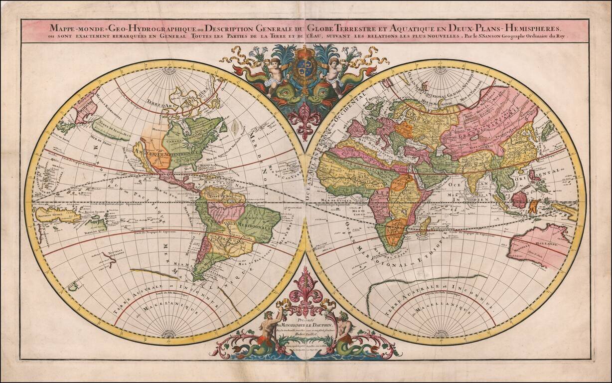
Striking Double Hemisphere World Map
Elegant double hemisphere world map published by Alexis-Hubert Jaillot, featuring the latest discoveries and decorative embellishments. Particularly interesting geographic features include California as an island, a sparse and unknown southern continent, and the recent coastal encounters in New Zealand, Australia, and Van Diemen’s Land (Tasmania).
The dual hemispheres are contained within a relatively simple frame which centers the map’s geography as the most important component. The title is enclosed in a simple banner at top of the map frame and notes the original creator of this map as renowned French cartographer Nicolas Sanson. Jaillot worked with Nicolas Sanson’s sons and reworked and re-released many of his maps.
At the juncture of the two hemispheres are the decorative elements of the map. At bottom, two large mermen keep a flower-framed cartouche from falling into the sea. The fleur-de-lis, an important symbol in French culture, adorns the top of the frame. Above the hemispheres, cherubs ride dolphins and hold the coat of arms of the Dauphin. The map is dedicated to the Dauphin, Louis de France, who was to inherit the throne when his father, Louis XIV, died. However, Louis died of smallpox in 1711, four years before his father succumbed to a gangrenous infection. Therefore, he never became King; instead, his grandson was crowned Louis XV.
The eastern hemisphere includes a remarkably complete western portion of Australia, based on Dutch encounters with the continent dating from the early seventeenth century. To the south is an immense coastline left unfinished as it meanders to the east. This is the great Southern Continent, assumed to exist to counterbalance the northern continental landmasses but in 1691 still a mere idea.
North America is divided to show the various imperial powers then vying for control of the continent. Spain controlled what is labeled here as California (an island), New Mexico, New Spain, and Florida. To the north is the vast forested expanse of New France, while the tiny English colonies cling to the Eastern seaboard. The northwest coast is left blank, said to house the outlet of a Northwest Passage to China. Searches for this passage have helped to fill in the northeast of the continent, although Greenland is connected to Canada and the precise extent of Baffin’s Bay and Hudson’s Bay remain unknown. This map also provides an early delineation of the Great Lakes.
Evidence of Maarten Gerritz de Vries 1643 expedition in the southern Kuril Islands area is reflected on this map: the de Vries Strait, Cape Patience, Staten Land (Terre des Estats), and Company Land (Terre de la Compagnie) are all marked. Terre de Iesso, likely a misconception of the Japanese island of Hokkaido, was reported by de Vries as smaller islands. Mapmakers over time re-envisioned Iesso and Company’s Land as a land bridge connected to America. The cartography of this map leaves these options open: Terre de Iesso, drawn only partially and separated from California, seems to suggest connection to North America.
Pivotal Pacific discoveries and a shrinking Southern Continent
The mythical southern continent, Terre Australe et Inconnue dite Magellanique is included on this map but is drawn very sparsely. Terre de Quir is also shown on this map, a reference to Pedro Fernández de Quirós’ 1605 expedition in search of the continent. Quirós’ account of land he encountered was used interchangeably as an island or as proof of the southern continent on numerous maps.
Jacob Le Maire and Willem Schouten’s circumnavigation to undermine the trade monopoly of the Dutch East India Company (VOC) resulted in a number of cartographic changes. Their discovery of the Le Maire Strait marked a new passage into the Pacific that avoided the Strait of Magellan, which was the exclusive purview of the VOC. This voyage was pivotal for showing that Tierra del Fuego was not part of the Southern Continent as had been previously believed.
Although Abel Tasman’s expeditions were viewed as failures by his employers at the Dutch East India Company (VOC)—he did not provide a novel shipping route or trade possibility-his contributions to cartographic knowledge of the region were important. Over the course of his two major expeditions (1642-1644), Abel Tasman recorded much of the coasts of Australia (New Holland), part of Tasmania (which he named Van Diemen’s Land) and the west coast of New Zealand. His loose circumnavigation of Australia proved that the Australian continent was separate from the unknown southern continent.
After Tasman’s circumnavigation of Australia, the southern continent began to shrink in cartographic depictions. The idea of a sprawling southern continent was eventually disproven by James Cook’s first (1768) and second (1772) voyages through the southern Pacific.
New Guinea is shown as a large island. In a conservative move, Carpentaria is not clearly connected to either Australia or New Guinea, revealing uncertainty about the geography of the area.
California as an island
Although the earliest maps of North America portrayed California correctly as a peninsula, the myth of California as an island was most likely the result of a reading of the travel account of Sebastian Vizcaino, who had been sent north up the shore of California in 1602. A Carmelite friar who accompanied him later described the land as an island, a description first published in Juan Torquemada’s Monarquia Indiana (1613) with the island details curtailed somewhat. The friar, Fray Antonio de la Ascension, also wrote a Relacion breve of his geographic ideas around 1620.
These ideas spread in Spain and New Spain and, eventually, most likely via Dutch mariners and perhaps thanks to stolen charts, to the rest of Europe. Prominent practitioners like John Speed, Jans Jansson, and of course Nicolas Sanson, as seen here, adopted the new island and the practice became commonplace.
Father Eusebio Kino, after extensive travels in what is now California, Arizona, and northern Mexico concluded that the island was actually a peninsula and published a map refuting the claim (Paris, 1705). Despite Kino’s work, California as an island remained a fixture on maps until the mid-eighteenth century, mostly due to political reasons.
States of this map
This map is an enlarged version of Nicolas Sanson’s original world map. Jaillot worked with Sanson’s sons Guillame and Adrien to publish this work. From 1681, the map was incorporated into Jaillot’s Atlas Nouveau.
Plate I includes the signature of the engraver Cordier, and comes in four states dated 1674, 1679, 1681, and 1684. Plates II-IV are not signed by Cordier. Plate II, dated 1674 uses the Latin “v” for “u”, and is dated 1674 although Shirley notes it may predate Plate I. Plate III is dated 1687. Plate IV was newly engraved for the Atlas Nouveau of 1691, and comes in three states. The second state of Plate IV is dated 1696, and its third state is undated.
This map, not dated, is a fine example of the third state of Plate IV.
If you are a student, write to us in telegram: @antiquemaps and indicate what material you need and for what work you need a map in high detail. We are ready to provide material on special terms. For students only!


