logo

1804. Mappe-Monde dressee suivant les nouvelles relations et assujettie aux observations astronomiques . . . Corrigee et augementee des decouvertes du Cap. Cook, de ses trois Voyages de celles de la Perouse, en 1801 de Vancouver, de MacKenzie in 1802 . . . An X

  • Mappe-Monde dressee suivant les nouvelles relations et assujettie aux observations astronomiques . . . Corrigee et augementee des decouvertes du Cap. Cook, de ses trois Voyages de celles de la Perouse, en 1801 de Vancouver, de MacKenzie in 1802 . . . An X

Mappe-Monde dressee suivant les nouvelles relations et assujettie aux observations astronomiques . . . Corrigee et augementee des decouvertes du Cap. Cook, de ses trois Voyages de celles de la Perouse, en 1801 de Vancouver, de MacKenzie in 1802 . . . An X information:

Year of creation: 
Resolution size (pixels): 
 18179x11718 px
Disk Size: 
 56.0695MiB
Number of pages: 
 1
Place: 
 Paris
Author: 

Print information. Print size (Width x height in inches):
Printing at 72 dpi 
  252.49 х 162.75
Printing at 150 dpi 
 121.19 х 78.12
Printing at 300 dpi 
 60.6 х 39.06

An example of detailing the file of this map of in a printable high-resolution:

Click to open in high resolution (open in new tab).
Attention! this is just the central piece (central area 960x960 px) of the map file!
This is an example, so that you can see and study the level of detail of a given map. The entire Map will be fully available after payment!

Mappe-Monde dressee suivant les nouvelles relations et assujettie aux observations astronomiques . . . Corrigee et augementee des decouvertes du Cap. Cook, de ses trois Voyages de celles de la Perouse, en 1801 de Vancouver, de MacKenzie in 1802 . . . An X

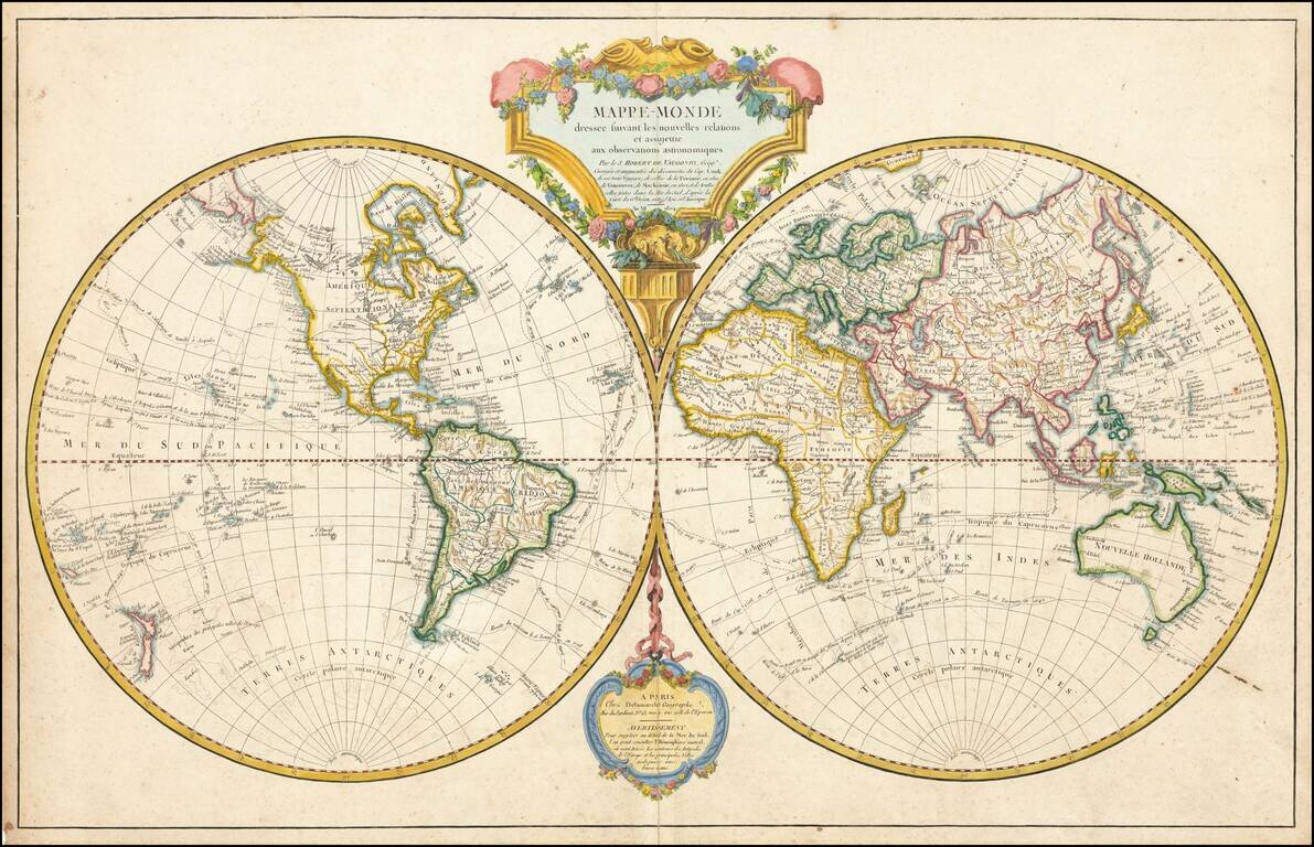
Including The Antipodes of the principal European Cities in the Southern Hemisphere

Striking double hemisphere map of the world, revised to include the recent discoveries of Captain James Cook, La Perouse and Vancouver.

The map includes tracts of European voyages in the Pacific and elsewhere. Included are the notes of the voyages of Tasman, Le Maire, Vancouver, Cook, MacKenzie, St. Louis, Vaisseaux, Anson, Cabadonga and others.

While many of the major discoveries in the Pacific are now shown, including a relatively accurate New Zealand, Australia and NW Coast of America, the details in these regions are far from accurately refined.

A curious coastal outline is shown in the Antarctic and South Pacific (western hemisphere), mirroring the geography of Europe (The Antipodes of the principal European Cities).


Special conditions for students!

If you are a student, write to us in telegram: @antiquemaps and indicate what material you need and for what work you need a map in high detail. We are ready to provide material on special terms. For students only!

Item information:

Year of creation:
Size:
18179x11718 px
Disk:
56.0695MiB
Number of pages:
1
Place:
Paris
Author:
Felix Delamarche.
$14.99

Related item