logo

1819. Mappa Dioecesis Alba-Regalensis, Per Inclytos Comitatus Albensem et Pilsiensem extensae ac in duos Archi Diaconatus divisae. Delineata per Joan: Pongratz Anno MDCCCXIX

  • Mappa Dioecesis Alba-Regalensis, Per Inclytos Comitatus Albensem et Pilsiensem extensae ac in duos Archi Diaconatus divisae. Delineata per Joan: Pongratz Anno MDCCCXIX

Mappa Dioecesis Alba-Regalensis, Per Inclytos Comitatus Albensem et Pilsiensem extensae ac in duos Archi Diaconatus divisae. Delineata per Joan: Pongratz Anno MDCCCXIX information:

Year of creation: 
Resolution size (pixels): 
 14931x20440 px
Disk Size: 
 93.9339MiB
Number of pages: 
 1
Place: 
 Budapest
Author: 

Print information. Print size (Width x height in inches):
Printing at 72 dpi 
  207.38 х 283.89
Printing at 150 dpi 
 99.54 х 136.27
Printing at 300 dpi 
 49.77 х 68.13

An example of detailing the file of this map of in a printable high-resolution:

Click to open in high resolution (open in new tab).
Attention! this is just the central piece (central area 960x960 px) of the map file!
This is an example, so that you can see and study the level of detail of a given map. The entire Map will be fully available after payment!

Mappa Dioecesis Alba-Regalensis, Per Inclytos Comitatus Albensem et Pilsiensem extensae ac in duos Archi Diaconatus divisae. Delineata per Joan: Pongratz Anno MDCCCXIX

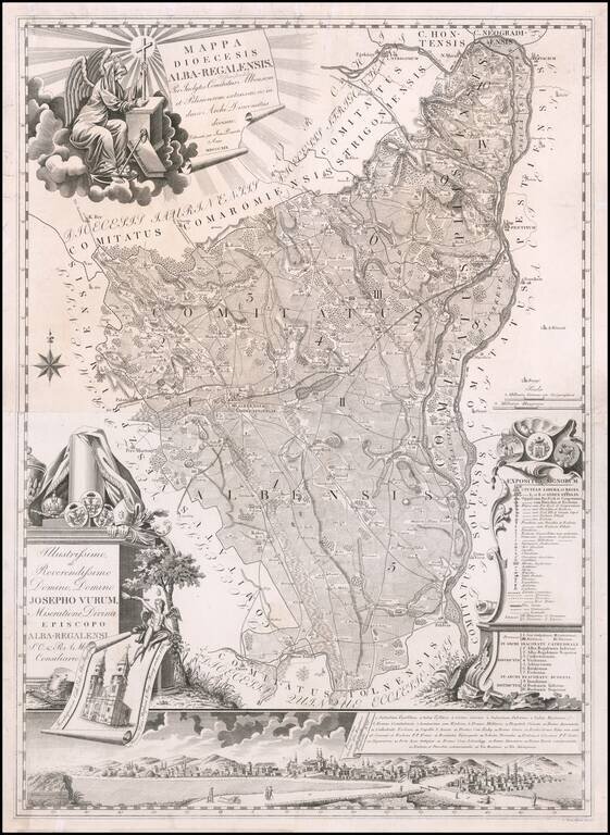
Rare two sheet map of Albensis (Fejér) in Hungary by Janor Pongratz.

The map is centered on Székesfehérvár with the Danube River at the right, intersecting the towns of Buda and Pest.

The name Stuhlweißenburg appears in pencil in the title. Stuhlweißenburg translates in English as White Castle. Székesfehérvár, is known colloquially as Fehérvár (white castle in Hungarian) and İstolni Belgrad ( also white castle in Ottoman Turkish).

Pongratz was an Hungarian engraver and military cartographer and served as a lieutenant in the second Royal Imperial Artillery Regiment. He also produced a map of Germany in 6 sheets, and a post road map of Europe which was published by Tranquillo Mollo in Vienna.

Engraved by Ferenc Karacs (1770-1838), an Hungarian engraver who studied at Debrecen, Pest and Vienna. He learned his engraving technique at the workshop of Junker and Czetter. He became famous and was invited to work in St. Petersburg, Russia by the Czar, but declined and worked mainly from Pest where he was the first to set up a printing press capable of the production of large-size map sheets from copperplate engravings.


Special conditions for students!

If you are a student, write to us in telegram: @antiquemaps and indicate what material you need and for what work you need a map in high detail. We are ready to provide material on special terms. For students only!

Item information:

Year of creation:
Size:
14931x20440 px
Disk:
93.9339MiB
Number of pages:
1
Place:
Budapest
Author:
Janor Pongratz.
$21.99

Related item