logo

1866. Map of the Vicinity of Petersburg. Taken from Surveys made by Order of Maj. Gen. J.F. Gilmer . . .

  • Map of the Vicinity of Petersburg.  Taken from Surveys made by Order of Maj. Gen. J.F. Gilmer . . .

Map of the Vicinity of Petersburg. Taken from Surveys made by Order of Maj. Gen. J.F. Gilmer . . . information:

Year of creation: 
Resolution size (pixels): 
 1460x2171 px
Disk Size: 
 1.32895MiB
Number of pages: 
 1
Place: 
 n.p.

Print information. Print size (Width x height in inches):
Printing at 72 dpi 
  20.28 х 30.15
Printing at 150 dpi 
 9.73 х 14.47
Printing at 300 dpi 
 4.87 х 7.24

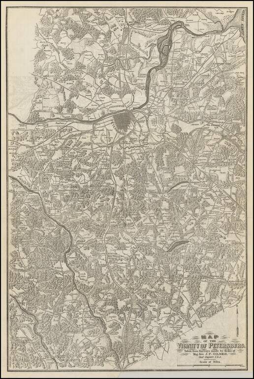
Scarce map of the vicinity of Petersburg, extending from the region just north of the James River to the state line with North Carolina.

The map is exceptionally detailed and shows towns, court houses, roads, railroads, rives, woods and the names of over 100 land owners.

No example appears in the dealer catalogue price records in the past 30 years.


Special conditions for students!

If you are a student, write to us in telegram: @antiquemaps and indicate what material you need and for what work you need a map in high detail. We are ready to provide material on special terms. For students only!

Item information:

Year of creation:
Size:
1460x2171 px
Disk:
1.32895MiB
Number of pages:
1
Place:
n.p.
Author:
Jeremy Francis Gilmer.
$9.99

Related item