Map size in jpg-format: 1.63824MiB
Click to open in high resolution (open in new tab).

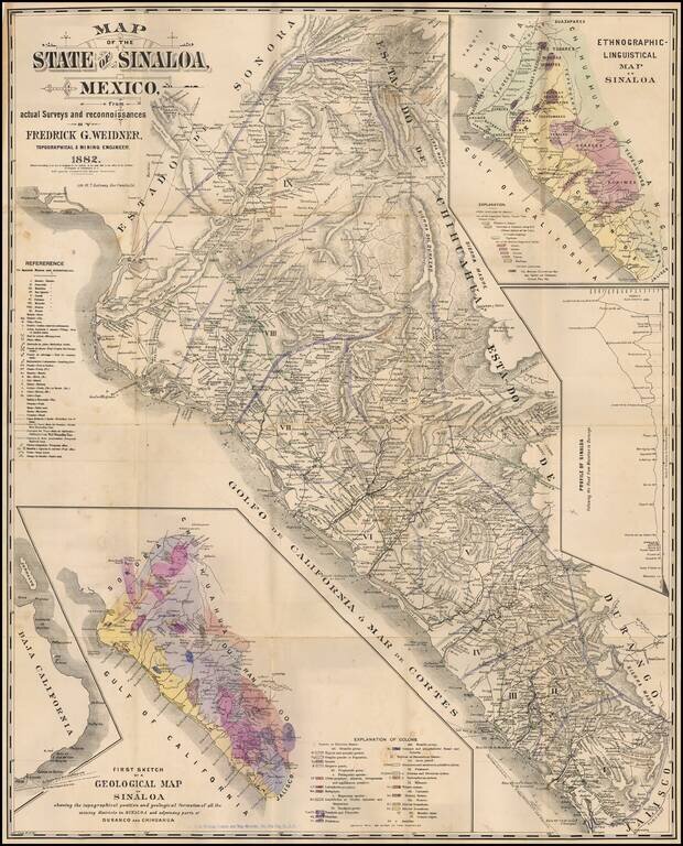
Rare map of Sinaloa in northwestern Mexico, lithographed by W.T. Galloway and published in San Francisco in 1882.
While created for the mining industry, the map's most unique features is the large inset "Ethongraphic-Linguistic Map of Sinaloa," documenting 9 "LIving Languages of Sinaloa."
A second map at the bottom shows the "First Sketch of a Geological Map of Sinaloa. A Third inset is a "Profile of Sinaloa, following the road from Mazatlan to Durango,"
This map was issued with a 19-page pamphlet, Map of Sinaloa with Statistical and Geological Notes, and apparently separately as well.
Fredrick Weidner was a civil and mining engineer who was working in Mexico as early as the mid-1860s. In testimony of David J. Garth, given to the US Senate Committee on Foreign Reiations on October 2, 1888, Garth reported that Weidner was a German metallurgis and mining enginer.
OCLC lists two copies of the map, locating one of them (at the Huntington); three copies of the pamphlet with the map (two at UC Berkeley and one at the University Forschungsbibliothek Erfurt Gotha), and two copies of the book with no mention of the map (at the Huntington and the New York Historical Society).
On the back of the map is the ink signature of L. Janin, a well-known mining engineer.
Provenance: Warren Heckrotte Collection: PBA Galleries March 2016; Ross Valley Book Company, June 1987.
If you are a student, write to us in telegram: @antiquemaps and indicate what material you need and for what work you need a map in high detail. We are ready to provide material on special terms. For students only!


![Map of Mexico, Central America, and the West Indies [Insets of Bermuda, Sandwich Islands, Jamaica and Panama Railroad]](/map/small/69133.jpg)