Map size in jpg-format: 33.9236MiB
Click to open in high resolution (open in new tab).

The Thomas Winthrop Streeter Copy
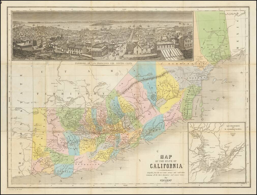
Rare hand-colored engraved map of California with east at the top. The map includes a very nice inset view of San Francisco ("Panorama of San Francisco and Contra Costa") and a further inset of "San Francisco and its surrounding localities. 1860".
The view is from the top of the hill, looking down Market St. and out across the Bay, affording a splendid prospect of the principal part of the city. The buildings are carefully and accurately drawn.
Wheat says of the map, "Many towns are shown in the mining region, but the map is neither as complete nor as accurate as might have been expected, considering its date. It is, however, a very decorative and charming affair."
Printed by Mangeon S Jacques St. The Benicia to Marysville railroad and the San Francisco to San Jose railroad are shown.
Interesting details in Southern California, though San Bernardino County is partially covered by the San Francisco view.
Rarity
Only five examples listed in OCLC.
The only other copy to have sold in the last 50 years was the Heckrotte example in 2015.
Provenance: This is the Eberstadt-Streeter-Howell copy. Eberstadt sold the map to Streeter in 1928. The map was sold as item #2857 in the Thomas W. Streeter Sale in 1968, purchased by Warren Howell, who offered it for sale in his 1979 Catalog for $400. The map has been in private collections thereafter, although it was offered by Dorothy Sloan Books in 2005 with a $4000-$8000 estimate.
If you are a student, write to us in telegram: @antiquemaps and indicate what material you need and for what work you need a map in high detail. We are ready to provide material on special terms. For students only!
![[Chinese-Language San Francisco Chinatown Business Directory and Lunar Calendar for 1892]](/map/small/66981jc.jpg)
![[San Francisco Fire Satirical Cartoon] Uncle Sam --](/map/small/70102.jpg)