Map size in jpg-format: 846410B
Click to open in high resolution (open in new tab).

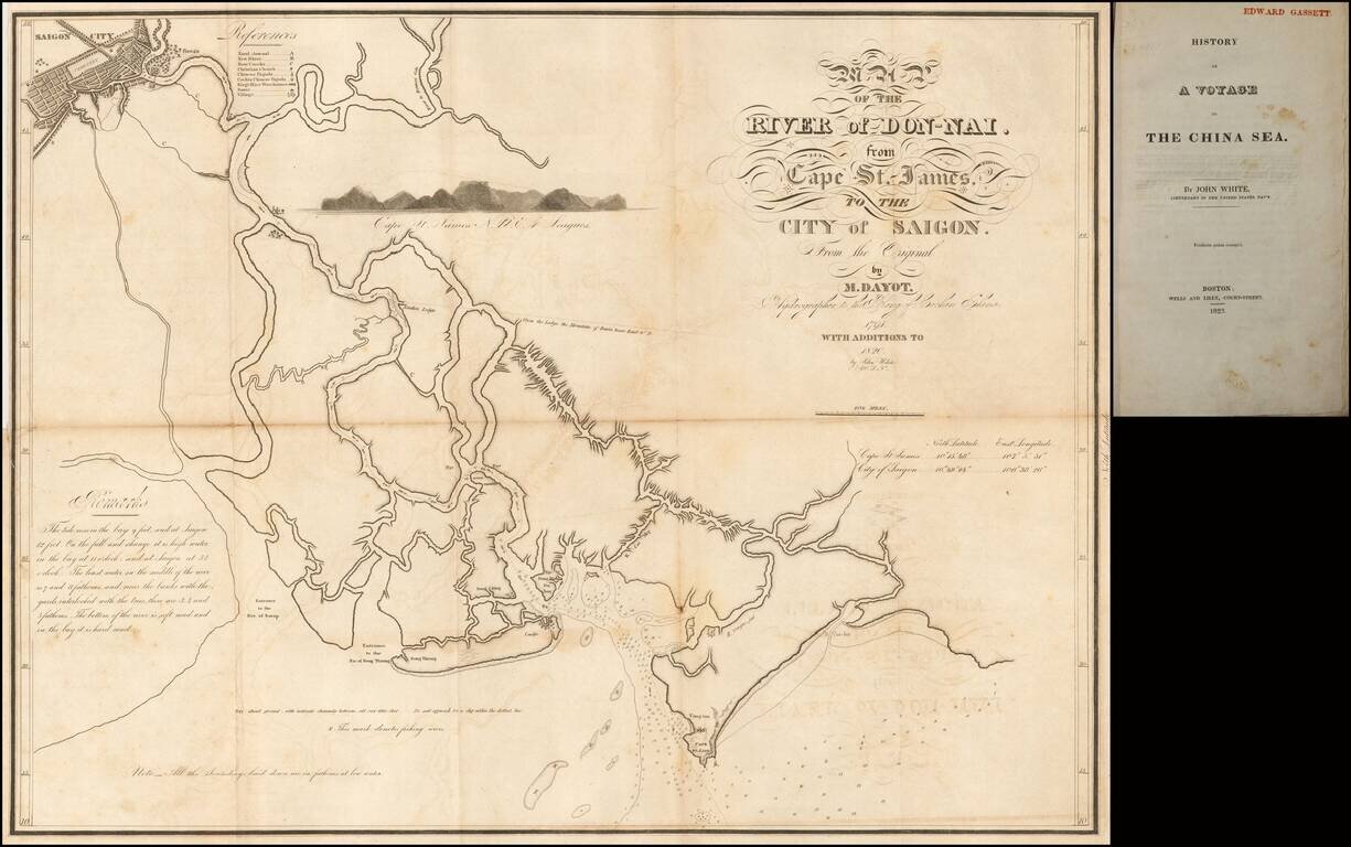
Scarce American map of the Don-Nai River from Saigon (Ho Chi Minh City) to the Sea, based upon the work of American, John White, which appeared in his History of A Voyage To The China Sea.
White's map improves on the mapping of the region by Jean Marie Dayot, drafted in 1790. The map also locates the Canal which at the time was intended to connect the Mekong Delta with the Dong-Nai, in an attempt to improve the commercial prospects of Saigon and the region.
Captain John White was a member of the East India Marine Society of Salem, Massachusetts. White sailed from Salem aboard the US Navy brig Franklin in 1819, arriving in Saigon on October 7, 1819. His visit is the second earliest recorded American visit and among the earliest to ascend the Dong Nai River to Saigon, where he spent a considerable amount of time, sufficiently so that he was able to update Dayot's earlier map.
Jean Baptiste Marie Dayot (1759-1809) was a French Naval Officer who wound up working in the service of Nguyen Anh, who would go on to become Emperor Gia Long of Vietnam. He arrived in Vietnam aboard the warship Meduse, where he remained. By 1790, he had command of the Vietnamese Navy, which consisted of 2 European Warships owned by Anh. Dayot undertook the mapping of the coastline of Vietnam, assisted by his brother. Dayot's service ended in 1795, when he stranded one of his ships. He moved on to Manilla, where he traded with Mexico until his ship, the Gulf of Tonkin, sunk in 1809.
If you are a student, write to us in telegram: @antiquemaps and indicate what material you need and for what work you need a map in high detail. We are ready to provide material on special terms. For students only!
![[Signed Political Satire Artwork] Vietnam ... Vietnam ... Vietnam ...](/map/small/68726.jpg)
![[Martin Behaim Globe / Book] Pars Globi terrestris Ao. 1492 a Martino Behaim Equite Lusitano Norimbergae confecti Delineavit Christoph. Theoph de Murr 1778 (bound with:) Diplomatische Geschichte des Portugesischen berühmten Ritters Martin Behaims](/map/small/68828.jpg)
![Il Disegno Della Terza Parte Dell' Asia [Gastaldi's Wall Map of SE Asia with extra panels!]](/map/small/30554hbp.jpg)