logo

1881. Map of the Harlaem Commons surveyed agreeably to the boundaries established by the Commissioners appointed to settle the boundary lines between the common lands of the City of New York and the Town of Harlaem...

  • Map of the Harlaem Commons surveyed agreeably to the boundaries established by the Commissioners appointed to settle the boundary lines between the common lands of the City of New York and the Town of Harlaem...

Map of the Harlaem Commons surveyed agreeably to the boundaries established by the Commissioners appointed to settle the boundary lines between the common lands of the City of New York and the Town of Harlaem... information:

Year of creation: 
Resolution size (pixels): 
 43550x15471 px
Disk Size: 
 133.791MiB
Number of pages: 
 1
Place: 
 Hoboken, NJ

Print information. Print size (Width x height in inches):
Printing at 72 dpi 
  604.86 х 214.88
Printing at 150 dpi 
 290.33 х 103.14
Printing at 300 dpi 
 145.17 х 51.57

An example of detailing the file of this map of in a printable high-resolution:

Click to open in high resolution (open in new tab).
Attention! this is just the central piece (central area 960x960 px) of the map file!
This is an example, so that you can see and study the level of detail of a given map. The entire Map will be fully available after payment!

Map of the Harlaem Commons surveyed agreeably to the boundaries established by the Commissioners appointed to settle the boundary lines between the common lands of the City of New York and the Town of Harlaem...

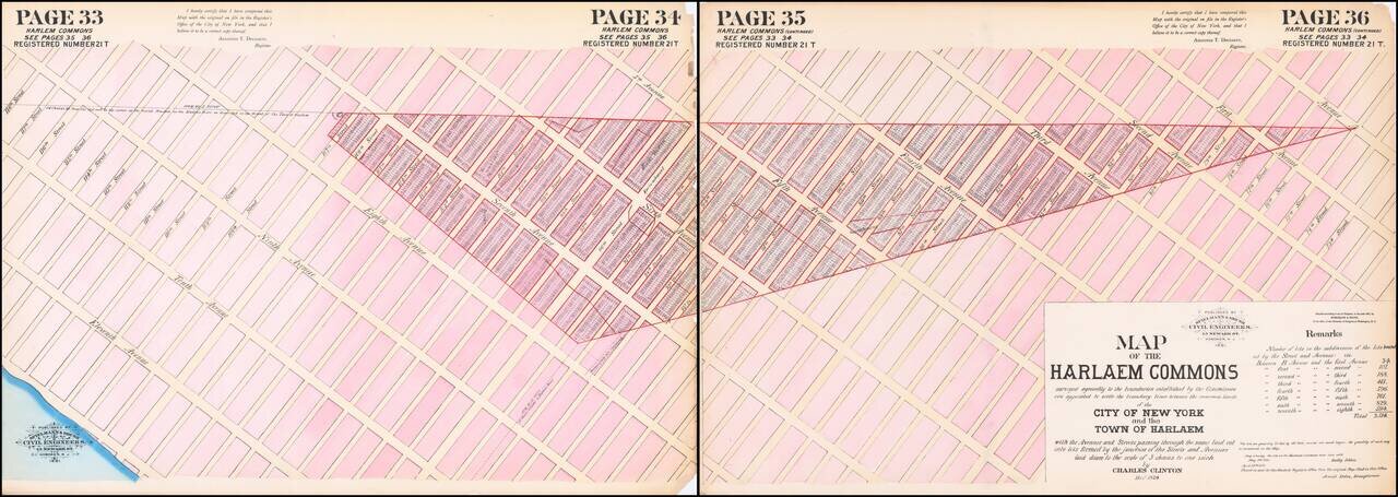
Hand-colored lithographed map of part of Harlem, New York City, published by Spielmann & Brush in their very rare atlas Certified Copies of Original Maps of Property in New York City (1881). The last copy of that atlas was on the market with a New York City bookdealer for $12,500.

The map shows old farm plots and roads, as well as modern streets and lots, bounded by modern-day Avenue A to 11th (West End) Avenue, and 118th Street and 73rd Street.

Much of the area shown on the map was covered by Central Park and the Croton (Jacqueline Kennedy Onassis) Reservoir, though it is not illustrated.

Based on an original survey by Charles Clinton completed in December 1824.


Special conditions for students!

If you are a student, write to us in telegram: @antiquemaps and indicate what material you need and for what work you need a map in high detail. We are ready to provide material on special terms. For students only!

Item information:

Year of creation:
Size:
43550x15471 px
Disk:
133.791MiB
Number of pages:
1
Place:
Hoboken, NJ
Author:
Spielmann & Brush. Charles Clinton.
$29.99

Related item