Map size in jpg-format: 66.8529MiB
Click to open in high resolution (open in new tab).
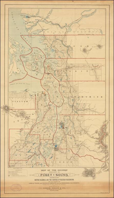
Rare separately published map of "the Puget Sound Country," published by Baker, Balch & Co. Civil, Mechanical and Electrical Engineers and lithographed by A. Zeese & Co. of Chicago.
A remarkable advertising map issued to promote settlement, development and tourism. The maps shows Puget Sound and the region to the east. The map south to include Mt. Rainier, which is drawn outside the map's neatline.
The map shows hydrography, railroads, Indian and government reservations, county and international boundaries, lighthouses, mineral resources and survey sections.
The Reference Key identifies Railways in Operation, Railways located and Constructed, Railways Projected, County Boundaries, International Boundaries and US Military, Naval and Light House Reserves. The map includes red overprinting, illustrating county lines.
The map is annotated in Orange (showing routes between major cities, etc.) and Blue (highlighting Seattle, Tacoma and Vancouver).
The map was prepared by Baker, Balch & Company of Seattle, in the year after Allan Balch moved to Seattle and joined the firm, after graduationg from Cornell in 1889. The firm seems to have expanded well beyond Seattle. In the firm's entry in Who's Who in Engineering in 1922-23, the firm seems to have expanded throughout the west coast, where they did a tremendous amount of Gas & Electricity work and also represented a number of larger municipalities.
Rarity
We locate a single example (New York Public Library).
If you are a student, write to us in telegram: @antiquemaps and indicate what material you need and for what work you need a map in high detail. We are ready to provide material on special terms. For students only!
![[Map of the United States, illustrating the routes of the Candian Pacific Railway and the Seattle, Lake Shore and Eastern Railway]](/map/small/71080.jpg)

