Map size in jpg-format: 49.7428MiB
Click to open in high resolution (open in new tab).
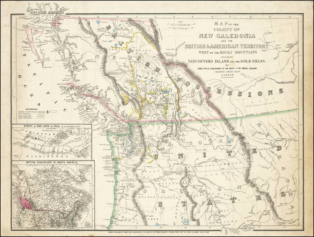
First State of this Exceptional Fraser Canyon Gold Rush Rarity
One of the great early mappings of the Pacific Northwest, covering Oregon Territory, Washington Territory, and British Columbia (which was then still "New Caledonia") with information derived from the Hudson Bay Company and Royal Engineers surveying activity in the region.
The Fraser Gold Rush had begun in 1858 and cartographic information was somewhat slow to make its way back to London. Thus this is one of the earliest and best maps for the region from this crucial era.
The map extends from Fort Hall in Oregon Territory in the south to the northern boundary of the Colony of British Columbia in the north. "Russian America" is labeled in the upper-left corner of the map, covering the present-day southern tip of the Alaskan panhandle. In the east, the map extends to the plains of Alberta and Montana.
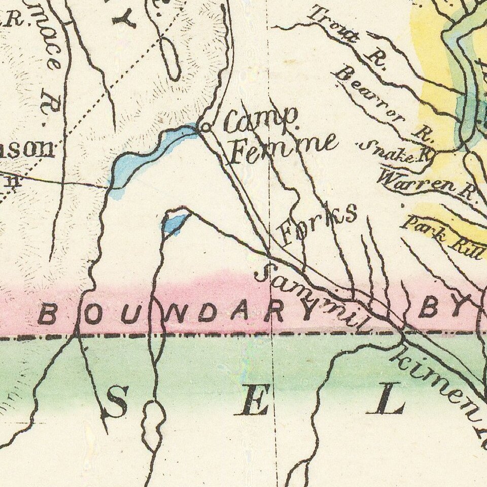
As is declared in the title, the map is concerned with gold mining and the key at the far left relates to it. The four entries there read "Primary or Crystalline Formation", "Coal Formation" (coal was an important resource in the Pacific Northwest with locations around Puget Sound and Gulf of Georgia), "Gold Formation", "Gold Workings". An additional symbol for "Coal Deposits" was seemingly lithographed as an afterthought in the bottom margin.
Vancouver Island (the Vancouver Island Colony) is shown as separate from the Colony of British Columbia. The map has two insets in the lower-left corner: "Strait of San Juan de Fuca on an Enlarged Scale" and "British Possessions in North America".
Gold Regions in Washington Territory
One of the map's noteworthy features is the numerous areas shown as gold diggings or otherwise colored to show gold in Washington Territory.
While largely a product of Fraser River Fever, the map certainly encourages the notion of gold in Washington Territory. Gold was first discovered in 1853 in the Yakima River Valley by a party under the command of Capt. George McClelland exploring a possible railroad route. By 1855, prospectors were active in the Colville district although the first discoveries were not made until 1883. In 1855, small placers were found along the Columbia and Pend Oreille Rivers. From the 1850s through the 1880s, placers were worked along streams in Okanogan, Whatcom, Chelan, and Kittitas Counties and along the major streams of the State - the Columbia and Snake Rivers.
States of the Map
There are 3 known states of the map, all extremely rare:
Rarity
We find the following copies of the
The Fraser Canyon Gold Rush
The Fraser Canyon Gold Rush, (also called the "Fraser River Gold Rush" or just the "Fraser Gold Rush") was a major gold rush that started in 1858 and was primarily centered around the Thompson and Fraser Rivers in present-day British Columbia (at the time the territory was known as New Caledonia and then the Colony of British Columbia). The Fraser Gold Rush was the impetus for the founding of British Columbia and the settlement of the region, including New Westminster and Vancouver. Following less than 10 years after the 1849 California Gold Rush, the Fraser Gold Rush attracted many former prospectors from the San Francisco Bay Area. Perhaps most famous among these was Ned McGowan who would become embroiled in a relatively bloodless set of events known as McGowan's War. Gold mining in the region continued until circa 1927, but by 1860 the gold-bearing sandbars of the Fraser River had already been depleted and most of the miners left the region with many returning to the United States.
James Wyld Sr. (1790-1836) was a British cartographer and one of Europe’s leading mapmakers. He made many contributions to cartography, including the introduction of lithography into map printing in 1812.
William Faden, another celebrated cartographer, passed down his mapmaking business to Wyld in 1823. The quality and quantity of Faden’s maps, combined with Wyld’s considerable skill, brought Wyld great prestige.
Wyld was named geographer to His Majesty George IV and William IV, as well as HRH the Duke of York. In 1825, he was elected an Associate of the Institution of Civil Engineers. He was one of the founding members of the Royal Geographical Society in 1830. Also in 1830, his son, James Wyld Jr., took over his publishing house. Wyld Sr. died of overwork on October 14, 1836.
James Wyld Jr. (1812-87) was a renowned cartographer in his own right and he successfully carried on his father’s business. He gained the title of Geographer to the Queen and H.R.H. Prince Albert. Punch (1850) described him in humorous cartographic terms, “If Mr. Wyld’s brain should be ever discovered (we will be bound he has a Map of it inside his hat), we should like to have a peep at it, for we have a suspicion that the two hemispheres must be printed, varnished, and glazed, exactly like a pair of globes.”
If you are a student, write to us in telegram: @antiquemaps and indicate what material you need and for what work you need a map in high detail. We are ready to provide material on special terms. For students only!