Map size in jpg-format: 25.3118MiB
Click to open in high resolution (open in new tab).
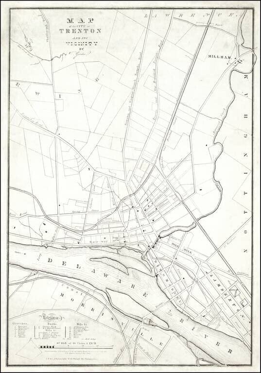
A Trenton Rarity
One of the earliest printed maps of Trenton, New Jersey, by one its most important early mapmakers.
The map was lithographed by "J.F. & C.A. Watson, Lithrs. No. 62 Walnut Street Philadelphia."
The map credits "T Gordon." This is almost certainly Thomas Gordon (1778-1848), a Trenton based lawyer and surveyor, who had previously been commissioned by the New Jersey legislature to create a map of New Jersey in 1828, which would become the official map of the state for several decades.
The Trenton Historical Society website includes the following entry:
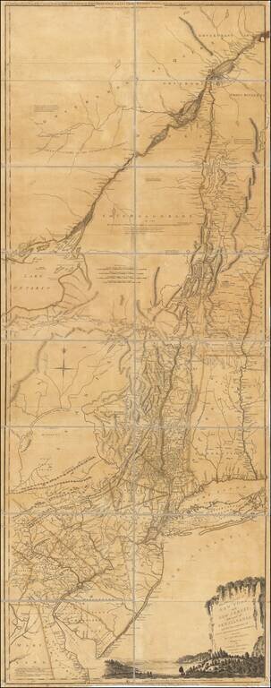
THE cartographic history of Trenton begins with the map of the present site of Trenton, drawn from surveys by William Emley in 1714 and found in Basse's Book of Surveys. A copy of this map is shown on page 26 and there is a facsimile on page 17 of Lee's History of Trenton. It was in this year that Mahlon Stacy, Jr., sold his plantation to Colonel William Trent. The title of the map is Mahlon Stacy's Plantation Surveyed by William Emley 6th month 12th 1714 . . .
The next maps of which there is any record are those prepared by the Hessian Lieutenants Piel, Wiederhold and Fischer, and knowledge of which we owe to the exhaustive research of the late General William S. Stryker in his admirable History of the Battle of Trenton. The originals of these maps were found in the King's State Archives at Marburg, Germany, and General Stryker reproduced them in his History.
General James Wilkinson, who fought at the Battle of Trenton, supplies the next map of the city in the "Diagrams and Plans" accompanying his Memoirs, published in 1816.
Other maps are as follows:
A Plan and Survey of Sundry pieces of Land adjoining the Delaware River and Assanpink Creek belonging to (D)an(iel) Cox 1789, (Manuscript.)
A Plan of Sundry lots of Land the Property of Daniel W. Coxe, Esq. Part of his Bloomsbury Estate. Circa 1800. (Manuscript).
Thomas Gordon, Map of Trenton and Vicinity. (The first wall-map of the city.) 1835.
Rarity
We locate copies at the New Jersey State Library and Princeton University.
If you are a student, write to us in telegram: @antiquemaps and indicate what material you need and for what work you need a map in high detail. We are ready to provide material on special terms. For students only!
![(American Revolution) [Manuscript Map of New York City and Northern New Jersey]](/map/small/69609.jpg)