Map size in jpg-format: 80.3627MiB
Click to open in high resolution (open in new tab).
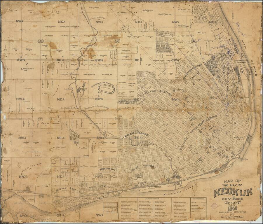
Finely executed cadastral map of Keokuk, published in 1895.
The map provides an excellent overview of the city, which at the time had a population of about 14,000.
The original townsite is shown, along with a number of later additions. The Keokuk District Fair and Half Mile Track are shown. Hand written annotations at the top left appear to have been added by an early real estate speculator.
A number of lines are shown radiating out away from the city block nearly Franklin and 8th Street, most extending through Grand Park.
Keokuk, Iowa
Situated between the Des Moines and Mississippi rivers, the area that became Keokuk had access to a large trading area and was an ideal location for settlers. In 1820, the US Army prohibited soldiers stationed along the Mississippi River from having wives who were Native American. Dr. Samuel C. Muir, a surgeon stationed at Fort Edwards (near present-day Warsaw, Illinois), instead resigned his commission rather than leave his Indian wife and crossed the river to resettle. He built a log cabin for them at the bottom of the bluff, and became the area's first white settler.
Around 1827, John Jacob Astor established a post of his American Fur Company at the foot of the bluff. Five buildings were erected to house workers and the business. This area became known as the "Rat Row".
The settlement was part of the land designated in 1824 as a Half-Breed Tract by the United States Government for allotting land to mixed-race descendants of the Sauk and Fox tribes. Native Americans considered the settlement a neutral ground. Rules for the tract prohibited individual sale of the land, but the US Congress ended this provision in 1837, creating a land rush and instability.
Centering on the riverboat trade, the settlement continued to grow. The village became known as Keokuk shortly after the Blackhawk War in 1832. Keokuk was incorporated on December 13, 1847. In 1853, Keokuk was one of the centers for outfitting Mormon pioneers for their journey west; more than 2,000 Mormons passed through the city.
If you are a student, write to us in telegram: @antiquemaps and indicate what material you need and for what work you need a map in high detail. We are ready to provide material on special terms. For students only!

![Amer. Sep. No. 49. Partie des États Unis [Missouri, Illinois, Indian Territory, Kansas, Nebraska, Iowa]](/map/small/22888.jpg)