Map size in jpg-format: 90.7583MiB
Click to open in high resolution (open in new tab).

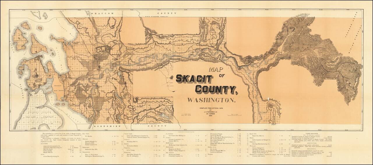
A highly detailed map of Skagit County, showing the county in great detail. The focal point of the map is the lumber industry within the county, with lumber and shingle mills noted in over twenty towns. The map identifies wagon roads, public roads, mines, and a number of other details. An interesting and unique aspect of the map is that detail is almost solely limited to areas along the principal rivers, places that could have been exploited the most easily.
The western part of Skagit County comprises part of the Pacific Northwest which has always been heavily dependent on lumber to sustain its economy. This is visible on the present map, which lists dozens of mills employing "600 to 800 woodsmen." Further details on the timber resources are noted, with over 500,000 acres of fir, cedar, larch, maple, cottonwood, alder, and various sorts of pine available. The agricultural economy of the region is also described, with 75,000 acres under cultivation producing oats, hay, hops, potatoes, carrots, and more. This is not so different than present-day production in Skagit County, where "field crops" and potatoes are still the leading products, although carrot production has ceased and blueberries have greatly risen in importance.
The educational statistics shown are particularly noteworthy. Three thousand students were educated in the county in 1893, taught by seventy-five students in fifty-nine schoolhouses.
The language in which employees are referred to is curious throughout the map. They are "required," and documented as a matter of primary importance. This perhaps speaks to systemic labor shortages in a county with an otherwise rapidly growing economy.
If you are a student, write to us in telegram: @antiquemaps and indicate what material you need and for what work you need a map in high detail. We are ready to provide material on special terms. For students only!
![[Map of the United States, illustrating the routes of the Candian Pacific Railway and the Seattle, Lake Shore and Eastern Railway]](/map/small/71080.jpg)

