logo

1949. Map of Newport Harbor Orange County California

  • Map of Newport Harbor Orange County California
  • Map of Newport Harbor Orange County California

Map of Newport Harbor Orange County California information:

Year of creation: 
Resolution size (pixels): 
 9735x10810 px
Disk Size: 
 48.0318MiB
Number of pages: 
 2
Place: 
 Balboa, California
Author: 

Print information. Print size (Width x height in inches):
Printing at 72 dpi 
  135.21 х 150.14
Printing at 150 dpi 
 64.9 х 72.07
Printing at 300 dpi 
 32.45 х 36.03

An example of detailing the file of this map of in a printable high-resolution:

Click to open in high resolution (open in new tab).
Attention! this is just the central piece (central area 960x960 px) of the map file!
This is an example, so that you can see and study the level of detail of a given map. The entire Map will be fully available after payment!

Map of Newport Harbor Orange County California

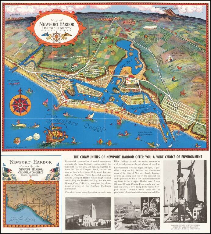
Decorative vintage pictorial promotional map of Newport Harbor and Newport Beach, California, issued by the Newport Harbor Chamber of Commerce.

This is the second of Claude Putnam's maps of Newport Harbor, with a prior edition issued in 1939.


Special conditions for students!

If you are a student, write to us in telegram: @antiquemaps and indicate what material you need and for what work you need a map in high detail. We are ready to provide material on special terms. For students only!

Item information:

Year of creation:
Size:
9735x10810 px
Disk:
48.0318MiB
Number of pages:
2
Place:
Balboa, California
Author:
Claude Putnam.
$14.99

Related item