Map size in jpg-format: 16.4359MiB
Click to open in high resolution (open in new tab).
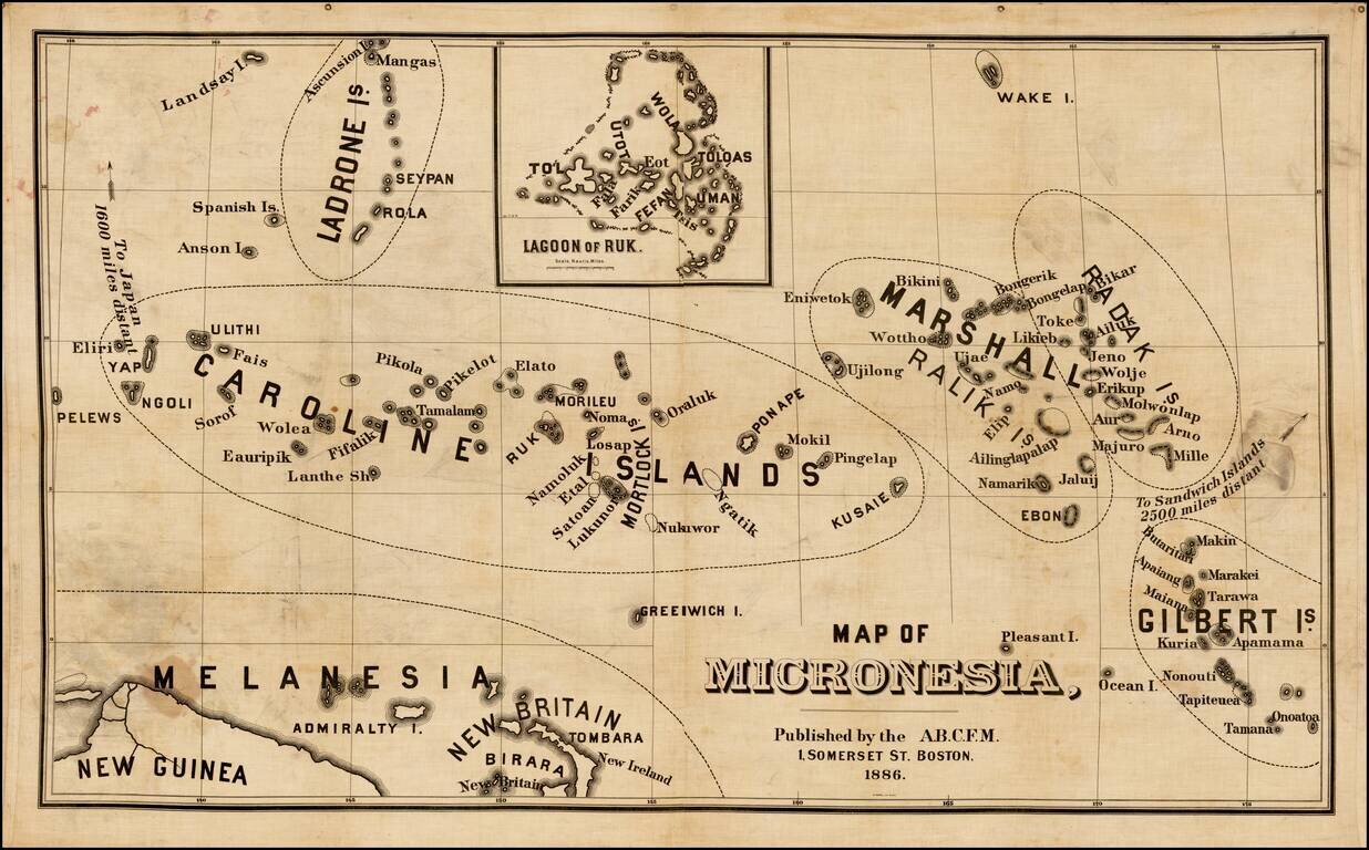
Rare map of Micronesia, published by the American Board of Commissioners for Foreign Missions in Boston.
The American Board of Commissioners for Foreign Missions (ABCFM) was the first American Christian missionary organization. It was created in 1810 by recent graduates of Williams College. In the 19th century it was the largest and most important of American missionary organizations.
The founding of the ABCFM was inspired by the Second Great Awakening. In 1806, five students from Williams College in western Massachusetts took shelter from a thunderstorm in a haystack. At the Haystack Prayer Meeting, they came to the common conviction that "the field is the world" and inspired the creation of the ABCFM four years later. The objective of the ABCFM was to spread Christianity worldwide.[1] Congregationalist in origin, the ABCFM also accepted missionaries from Presbyterian (1812-1870), Dutch-Reformed (1819-1857) and other denominations.
In 1812, the ABCFM sent its first missionaries -- Adoniram and Ann Hasseltine Judson; Samuel and Roxana Peck Nott; Samuel and Harriet Atwood Newell; Gordon Hall, and Luther Rice-to British India. Between 1812 and 1840, they were followed by missionaries to the following people and places: Tennessee to the Cherokee Indians, India (the Bombay area), northern Ceylon (modern day Sri Lanka), the Sandwich Islands (Hawaii); east Asia: China, Singapore and Siam (Thailand); the Middle East: (Greece, Cyprus, Turkey, Syria, the Holy Land and Persia (Iran)); and Africa: Western Africa-Cape Palmas-and Southern Africa-among the Zulus).
If you are a student, write to us in telegram: @antiquemaps and indicate what material you need and for what work you need a map in high detail. We are ready to provide material on special terms. For students only!
![[Martin Behaim Globe / Book] Pars Globi terrestris Ao. 1492 a Martino Behaim Equite Lusitano Norimbergae confecti Delineavit Christoph. Theoph de Murr 1778 (bound with:) Diplomatische Geschichte des Portugesischen berühmten Ritters Martin Behaims](/map/small/68828.jpg)
