Map size in jpg-format: 113.61MiB
Click to open in high resolution (open in new tab).
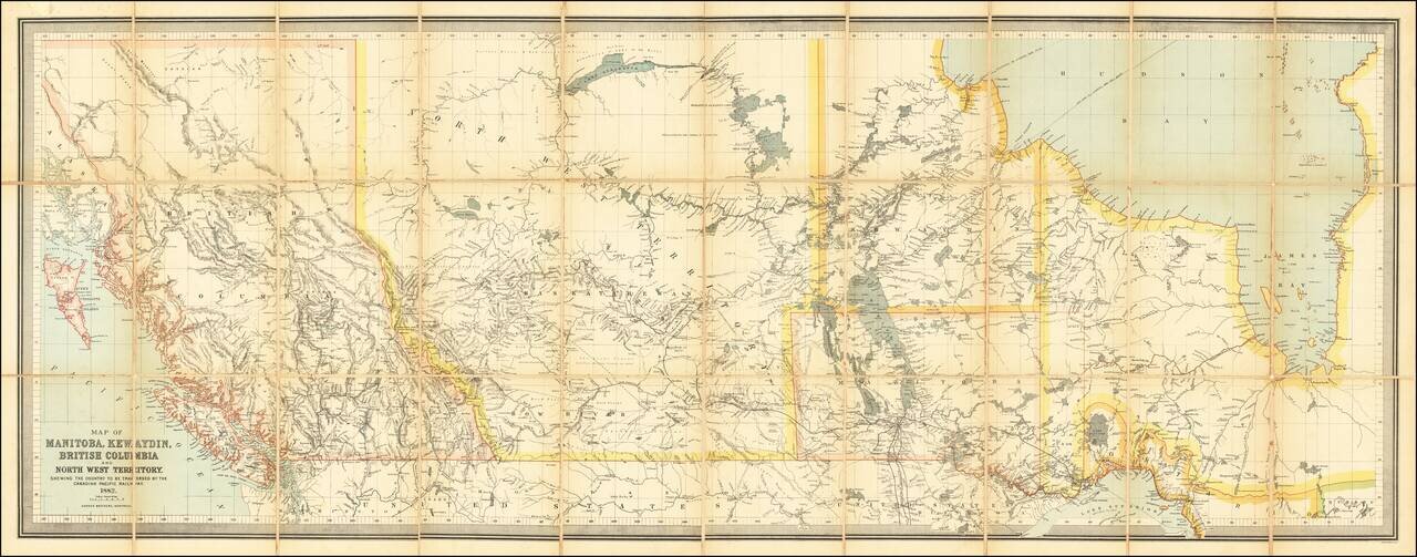
Impressive Canadian Railroad Map Showing the Proposed - But Never Realized - Province of Kewaydin.
Color-lithographed antique folding map of Canada west of Ontario, published in Montreal in 1882 by the Dawson Brothers.
The map features the Province of Kewaydin on the southwest shores of Hudson Bay - carved away from present-day Manitoba.
The map illustrates the course of the Canadian Pacific Railway and other realized and proposed railway lines.
The Province of Kewaydin
The Province of Kewaydin was a proposed province within Canada's northern territories in the mid-1880s. There is little written about the proposal today, and not all that much from contemporary sources either; this is the only map that we can find with Kewaydin shown. The following report covers the proposal of the province and its relationship to border disputes between Manitoba and Ontario: http://peel.library.ualberta.ca/bibliography/1190/9.html
Rarity
We find no examples offered for sale since 1956 (RBH).
If you are a student, write to us in telegram: @antiquemaps and indicate what material you need and for what work you need a map in high detail. We are ready to provide material on special terms. For students only!
![[The First Maps in a la poupée Printed Color] Cartes en Couleur des Lieux Sujets aux tremblements de Terre Dans toutes les parties du Monde Selon le Sisteme de l’impulsion Solaire](/map/small/52293op.jpg)

