Map size in jpg-format: 1.18668MiB
Click to open in high resolution (open in new tab).
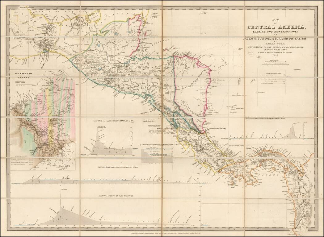
Early Edition of Wyld's map of Central America -- Including the first geological survey of Panama.
Fine map of Central America, which includes the first geological survey of Panama published in London by James Wyld.
This is the earliest edition of the map we have encountered. In the later editions of 1856 and 1862, the maps are continuously updated with new information and cartographic content.
In 1848, the discovery of gold in California not only caused would-be miners to flock to the Golden State, but also stimulated U.S. interest in a cross-ocean canal. A number of surveys carried out between 1850 and 1875, concluded that the two most favorable routes were those across Panama and across Nicaragua, with a route across the Isthmus of Tehuantepec in Mexico as a third option.
The present map includes 4 trans-isthmian profiles, showing the different proposed canal routes.
After the successful completion of the Suez Canal in 1869, the French were inspired to tackle a similar project which would connect the Atlantic and Pacific oceans. In 1876, an international company, La Société internationale du Canal interocéanique, was created to undertake the work. Ferdinand de Lesseps, who'd been in charge of the construction of the Suez Canal, was the figurehead of this scheme.
However, unlike the desert home of the Suez, Panama hosts the mountainous spine of Central America, which rises to a height of 110 meters above sea level at the lowest crossing point. Therefore, a sea-level canal, as proposed by de Lesseps, would require a prodigious excavation through harnesses of rock rather than through soft, desert sand.
The prospects for a canal are presented in a box on the left hand side of the map titled: Isthmus of Panama. The map is colored with reference to the geological makeup of the rock bed. The river and the brown coloring that make up the decomposed granite are well illustrated, being the easiest to move and dig through.
Construction of the canal began on January 1, 1881, however as early as 1885, it became clear that a sea-level canal was impractical, leading contractors to support an elevated canal. It was not until October 1887 that the lock-canal plan was adopted.
At this time, President Theodore Roosevelt and the Senate of the United States were interested in establishing a canal across the isthmus, with some favoring a canal across Nicaragua and others advocating the purchase of the French interests in Panama. In June 1902, the U.S. Senate voted in favor of pursuing the Panamanian option.
This edition of the map was issued in 1852. We are aware of later editions of 1856 and ca. 1862.
James Wyld was a geographer, map-seller, and member of the British Parliament. He is best known for Wyld's Great Globe, a hollow sphere which contained a staircase and elevated platforms, allowing the public to climb and view the surface of the Earth.
Wyld was the sole owner of a thriving family map-making business based in Charing Cross. His maps covered regions from London to the gold fields of California. His maps were highly regarded and he had, as his father before him, an excellent reputation as a map-maker. Wyld was elected as a fellow of the Royal Geographical Society in 1839 and was appointed Geographer to Queen Victoria and Prince Albert.
Wyld had an opportunistic approach to the business. He was not only a prolific publisher of maps and guides, but also a founder and patron of the Association of Surveyors and the Surveyors' Institution. He supported the Surveyors' Institution in an effort to lobby against the Ordinance Survey, as he felt its activities threatened his business. While his lobbying efforts failed, he did become one of the distributors of its printed maps.
If you are a student, write to us in telegram: @antiquemaps and indicate what material you need and for what work you need a map in high detail. We are ready to provide material on special terms. For students only!

![[Blaeu Atlas of America] America, Quae Est Geographiae Blavianae Pars Quinta Liber Unus Volumen Undecimum](/map/small/66852.jpg)
