Map size in jpg-format: 1.78076MiB
Click to open in high resolution (open in new tab).
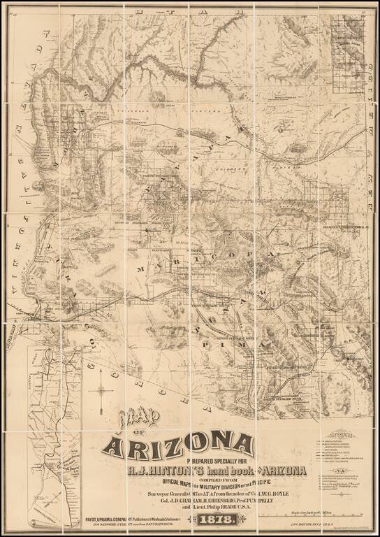
The First Privately Printed Large Format Map of Arizona Territory with Hinton's Hand Book.
Hinton's map of Arizona was intended to be published with his hand book. However, as noted by Streeter, the map was accompanied by a note that the book would not be ready until December of 1878, some months after the map.
Hinton's 1878 Hand-Book to Arizona: Its Resources, History, Towns, Mines, Ruins, and Scenery, is generally regarded as the earliest book on mining in Arizona.
As noted by Streeter:
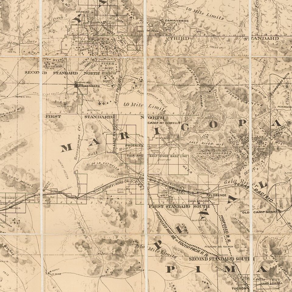
The northern boundary of Arizona is still the 37th parallel, but only to the 114th meridian. That meridian, south to the Colorado River at a little north of 36° and continuing along the Colorado, is now the western boundary. The line of the proposed Atlantic and Pacific R. R. is shown more or less along the line of the 35th parallel, with the Southern Pacific partially lined up along the Gila in Western Arizona.Hinton's map locates mining districts, the Indian reservations, towns, cities, counties, forts, camps, stage routes, landmarks, mountain ranges, creeks, rivers, mills, telegraph lines, etc. The line of the Atlantic and Pacific Railroad is shown with the grant lands marked 40 Mile Limits on either side of the route. The Southern Pacific follows the Overland Stage Route along the Gila River in western Arizona with its proposed route through Tucson and into the mining districts in the southern part of the territory.
There is an inset map: "Map of the Southern Pacific Railroad Connecting with the Central Pacific R.R. at Goshen 1877," which depicts the rail line from San Francisco to Yuma and the stopping points along the way.
This map along with the Eckhoff and Riecker map of Arizona issued in 1880, are the finest large scale maps of Arizona Territory issued in the 19th century. We have never seen this map bound in Hinton's book and the major collections auctioned in the past decades have the map separate from the book.
The present example of the map is offered with the Hinton book:
The Hand-Book of Arizona: Its Resources, History, Towns, Mines, Ruins and Scenery. Amply Illustrated. Accompanied with a New Map of the Territory San Francisco: Payot, Upham & Co, 1878. 431, [2], ci + 43 ad pp. With 22 lithographed plates & 6 lithographed maps & plans, 2 of them folding; inserted advertisement for Britton & Rey, who lithographed the plates and maps; plus large lithographed folding map. (12mo) 18.7x12 cm (7¼x4¾"), original blue cloth lettered in gilt with gilt cover vignette. First Edition.Provenance: Warren Heckrotte Sale, Pacific Book Auctions, December 2015. On the rear flyleaf is the pencil signature of A.E. Davis, identified as president of the South Shore Pacific Coast R.R.
If you are a student, write to us in telegram: @antiquemaps and indicate what material you need and for what work you need a map in high detail. We are ready to provide material on special terms. For students only!

![Mexique par Th. Duvotenay…1843 [Republic of Texas]](/map/small/67925.jpg)
