Map size in jpg-format: 16.2887MiB
Click to open in high resolution (open in new tab).

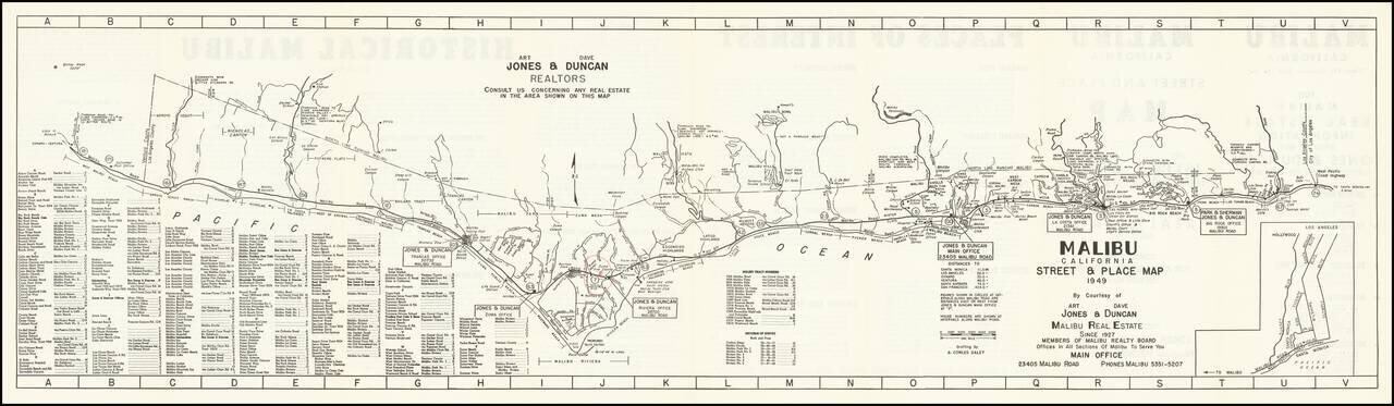
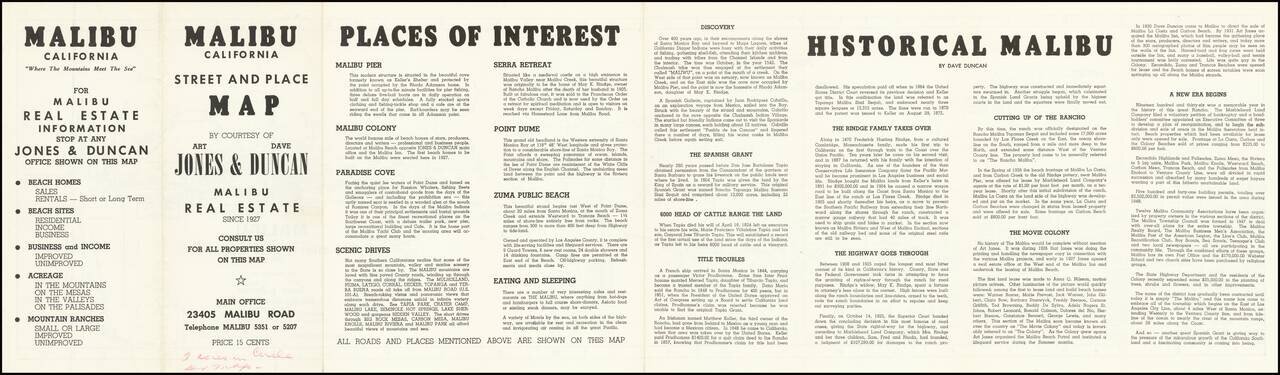
An Early Map of Malibu
Rare early promotional map of Malibu, California, published by Art. Jones & Dave Duncan, Realtors, published less than 20 years after the first subdivisions of the area by the Rindge family.
Stretching from Topanga Canyon Road to Little Sycamore Road just past the Ventura County Line, the map cover a 25 mile stretch of Coastline, the vast majority of which comprises Malibu.
The map is filled with early tourist points of interest, motels, cafes, yacht harbors, etc.
Malibu
Prior to California joining the union, the area was part of Rancho Topanga Malibu Sequit in 1802. That ranch passed intact to Frederick Hastings Rindge in 1891. He and his wife, Rhoda May Knight Rindge, assiduously avoided dividing the land. This including hiring guards to evict all trespassers and fighting a lengthy court battle to prevent a Southern Pacific railroad line through the ranch. Interstate Commerce Commission regulations would not support a railroad condemning property in order to build tracks that paralleled an existing line, so the Rindge's built the Hueneme, Malibu and Port Los Angeles Railway. The line started at Carbon Canyon, just inside the ranch's property eastern boundary, and ran 15 miles westward, past Pt. Dume.
In 1929, the state won a court case, which allowed it to build what is now known as the Pacific Coast Highway. By then May Rindge was forced to subdivide her property and begin selling and leasing lots. T
In 1926, in an effort to avoid selling land to stave off insolvency, May K. Rindge created a small ceramic tile factory. At its height, Malibu Potteries employed over 100 workers, and produced decorative tiles which furnish many Los Angeles-area public buildings and Beverly Hills residences.
Most of the Big Rock Drive area was purchased in 1936 by William Randolph Hearst, who considered building an estate on the property. He sold the lower half of his holdings there in 1944 to Art Jones. Jones was one of the prominent early realtors in Malibu, starting with the initial leases of Rindge land in Malibu Colony. He was also the owner/part-owner of the Malibu Inn, Malibu Trading Post and the Big Rock Beach Cafe (which is now Moonshadows restaurant).
If you are a student, write to us in telegram: @antiquemaps and indicate what material you need and for what work you need a map in high detail. We are ready to provide material on special terms. For students only!