Map size in jpg-format: 200.035MiB
Click to open in high resolution (open in new tab).
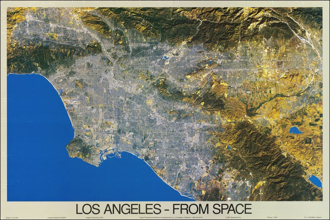
A fabulous color satellite image of Los Angeles, taken 450 miles from the surface of the earth. The scope of the image ranges from the San Fernando Valley to Laguna Beach, and inland past Riverside. The image was taken by EOSAT and printed at a scale of one inch to two and a third miles. The map preserves a fantastic view of the metropolis, surrounded by mountains, lakes, and ocean.
Many of the neighborhoods and regions of Los Angeles are here visible. The city center is evidently more built-up than the suburbs, and snaking through downtown are Interstate 5, Highway 101, and the Los Angeles River. USC and the Coliseum are visible just to the South East. The neighborhoods of Hollywood, Beverly Hills, East Malibu, Huntington Beach, and Compton can all be seen. The many ports of the city are visible, including San Pedro and Long Beach. Inland, one can see Mt. Baldy and Lake Elsinore.
The Library of Congress suggests that this is a true-color photograph, but some colors have been altered. Satellite images are commonly false-color for a variety of reasons. In the present image, bodies of water are all given the same blue color, which allows for a more homogenous shading. Were true-color to be used, each body of water would have looked very different, and the image would have reflected seasonal changes more than anything else, distracting the viewer. More curious is the choice to portray the hillsides with a yellow color. This isn't a flower bloom (California blooms take on an orange hue and 1987 was a poor flower season anyways) but rather another artistic choice. By comparison to true-color photographs, it appears that brown and grey shades are replaced with yellow. It is unclear if this is an attempt to spare Los Angles its true desert-like appearance, an attempt to bring out relief, or used for another purpose.
In the third of a century since this photo has been taken, Los Angeles has continued to expand. San Bernardino, once fields, is now an extension of the city, and the push through adjacent watersheds continues. The hydrology and lakes have changed as well. While several have shrunk and disappeared, a few have grown. 1987 was the first year of a severe drought in California, exemplifying the age-old problem of water crises in Southern California.
If you are a student, write to us in telegram: @antiquemaps and indicate what material you need and for what work you need a map in high detail. We are ready to provide material on special terms. For students only!