logo

1748. L'Irlande

  • L'Irlande

Map size in jpg-format: 8.91878MiB

Download "L'Irlande", in high resolution.

L'Irlande information:

Year of creation: 
Resolution size (pixels): 
 5281x7009 px
Disk Size: 
 8.91878MiB
Number of pages: 
 1
Place: 
 Paris
Author: 

Print information. Print size (Width x height in inches):
Printing at 72 dpi 
  73.35 х 97.35
Printing at 150 dpi 
 35.21 х 46.73
Printing at 300 dpi 
 17.6 х 23.36

An example of detailing the file of this map of in a printable high-resolution:

Click to open in high resolution (open in new tab).
Attention! this is just the central piece (central area 960x960 px) of the map file!
This is an example, so that you can see and study the level of detail of a given map. The entire Map will be fully available after payment!

L'Irlande

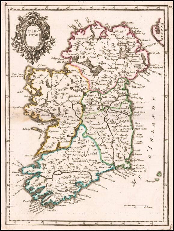
Beautiful small map of Ireland showing mountain ranges, cities, towns and sea ports.

The map appeared in Le Rouge's Nouvelle Atlas Portatif.


Special conditions for students!

If you are a student, write to us in telegram: @antiquemaps and indicate what material you need and for what work you need a map in high detail. We are ready to provide material on special terms. For students only!

Item information:

Year of creation:
Size:
5281x7009 px
Disk:
8.91878MiB
Number of pages:
1
Place:
Paris
Author:
Le Rouge.
$14.99

Related item