logo

1700. Le Duche De Brabant qui comprend les quartiers de Louvain. Brusselles, Anvers, et Bosleduc.

  • Le Duche De Brabant qui comprend les quartiers de Louvain.  Brusselles, Anvers, et Bosleduc.
  • Le Duche De Brabant qui comprend les quartiers de Louvain.  Brusselles, Anvers, et Bosleduc.
  • Le Duche De Brabant qui comprend les quartiers de Louvain.  Brusselles, Anvers, et Bosleduc.
  • Le Duche De Brabant qui comprend les quartiers de Louvain.  Brusselles, Anvers, et Bosleduc.

Le Duche De Brabant qui comprend les quartiers de Louvain. Brusselles, Anvers, et Bosleduc. information:

Year of creation: 
Resolution size (pixels): 
 21569x13992 px
Disk Size: 
 48.4436MiB
Number of pages: 
 4
Place: 
 Paris

Print information. Print size (Width x height in inches):
Printing at 72 dpi 
  299.57 х 194.33
Printing at 150 dpi 
 143.79 х 93.28
Printing at 300 dpi 
 71.9 х 46.64

An example of detailing the file of this map of in a printable high-resolution:

Click to open in high resolution (open in new tab).
Attention! this is just the central piece (central area 960x960 px) of the map file!
This is an example, so that you can see and study the level of detail of a given map. The entire Map will be fully available after payment!

Le Duche De Brabant qui comprend les quartiers de Louvain.  Brusselles, Anvers, et Bosleduc.

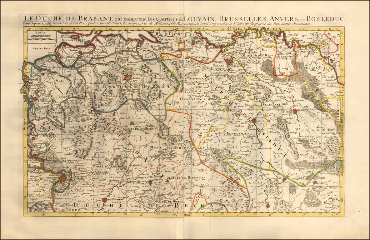
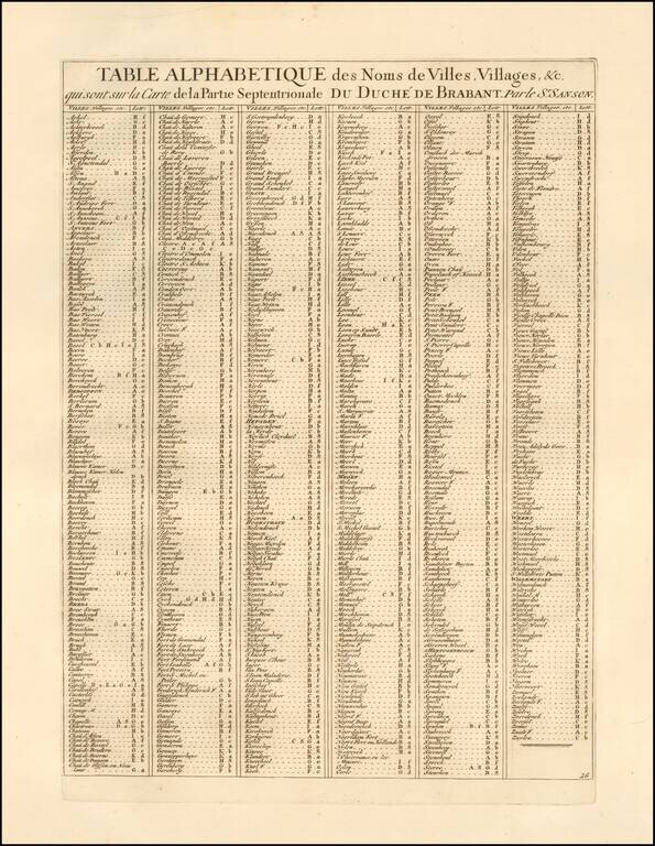
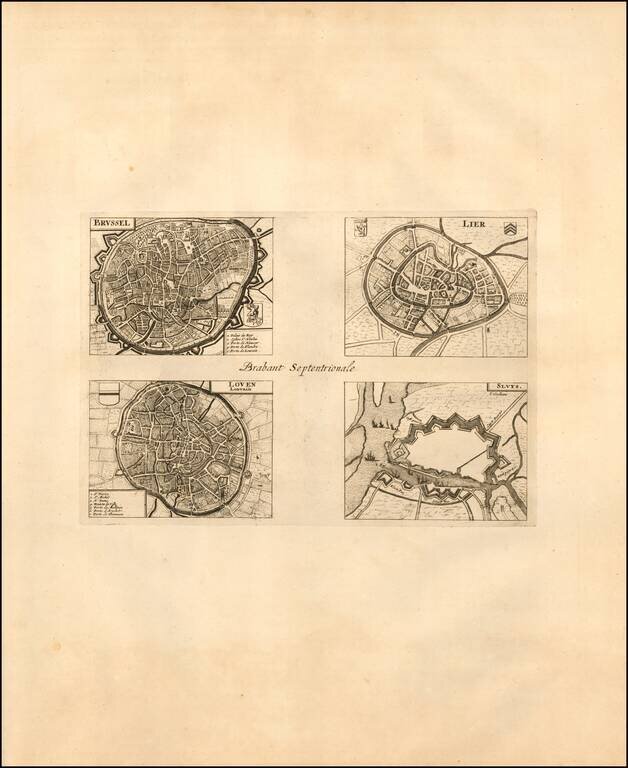
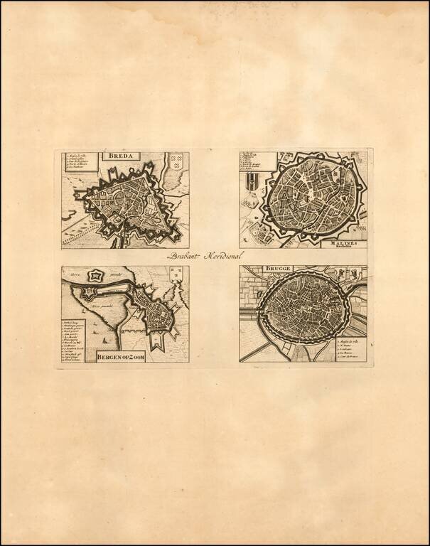
Map of the Duchy of Brabant which includes the districts of Leuven, Brussels, Antwerp, and Bosleduc. Includes 2 sheets with 4 city plans and/or views of the areas within northern and southern Brabant. Also includes an alphabetical table of towns and villages within the Duchy of Brabant.

The map illustrates the Duchy of Brabant, detailing the cities of Brussels, Lier, Leuven, Breda, Bruges, Mechelen, Bergen op Zoom, etc. A scale of distance is located at the top left of the map.

Alexis-Hubert Jaillot (ca. 1632-1712) was one of the most important French cartographers of the seventeenth century. Jaillot traveled to Paris with his brother, Simon, in 1657, hoping to take advantage of Louis XIV's call to the artists and scientists of France to settle and work in Paris. Originally a sculptor, he married the daughter of Nicholas Berey, Jeanne Berey, in 1664, and went into partnership with Nicholas Sanson's sons. Beginning in 1669, he re-engraved and often enlarged many of Sanson's maps, filling in the gap left by the destruction of the Blaeu's printing establishment in 1672.


Special conditions for students!

If you are a student, write to us in telegram: @antiquemaps and indicate what material you need and for what work you need a map in high detail. We are ready to provide material on special terms. For students only!

Item information:

Year of creation:
Size:
21569x13992 px
Disk:
48.4436MiB
Number of pages:
4
Place:
Paris
Author:
Alexis-Hubert Jaillot.
$21.99

Related item