Map size in jpg-format: 47.3652MiB
Click to open in high resolution (open in new tab).
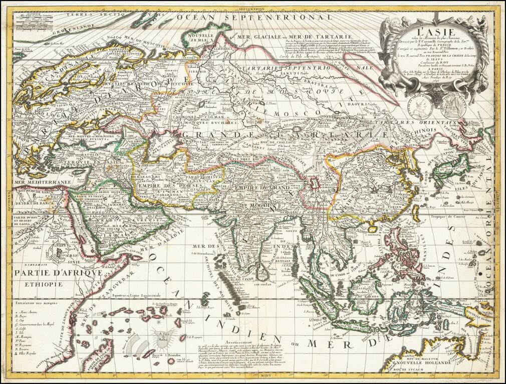
Nice example of Nolin's scarce map of Asia.
The map is the work of the remarkable collaboration between Venetian mapmaker Vincenzo Maria Coronelli and Jean Baptiste Nolin, who would later become the Royal Geographer under Louis XIV in 1701. The most famous product of Coronelli's time in Paris, working with Nolin, would be the remarkable 4 meter diameter globes created for Louis XIV, completed in 1683, which now reside in the Bibliothèque Nationale François Mitterrand in Paris.
Published after Coronelli's return to Venice, the map is an exceptional amalgam of the best information available to French mapmakers at the end of the 17th Century, crediting the following explorers and travelers:
The map provides an excellent treatment of Asia at the end of the 17th Century, including a depiction of the Great Wall of China and the Gobi Desert. The Northeastern coastal regions above Japan are still virtually unknown to western travelers and would remain so until the Russian explorations in the 18th Century.
The Philippines is still badly misshapen.
The Northern Coast of Australia is shown, including the Kingdom of Lucach (Roy de Lucach), a country far south of China mentioned by Marco Polo. The name is widely believed to be a variant of Lo-huk: the Cantonese name for the southern Thai kingdom of Lopburi (also known as Lavapura and Louvo), which was a province of the Khmer Empire at the time, but here appears in northwestern Australia, a remnant of its appearance in "Terra Australis" or the unknown southern continent on 16th Century maps. Similarly the Kingdom of Maletur, a Sumatran kingdom describe by Marco Polo, is also shown.
With the agreement of Coronelli (who receives credit in the title), Nolin issued this single sheet map of Asia, which first appeared circa 1688. While the map is based upon Coronelli's 2 sheet map of Asia, Coronelli's map did not appear in his Atlante Veneto until 1691.
If you are a student, write to us in telegram: @antiquemaps and indicate what material you need and for what work you need a map in high detail. We are ready to provide material on special terms. For students only!

![[Eastern Hemisphere Globe Gores] (Nova et integra universi Orbis descriptio)](/map/small/54480.jpg)