Map size in jpg-format: 47.4346MiB
Click to open in high resolution (open in new tab).
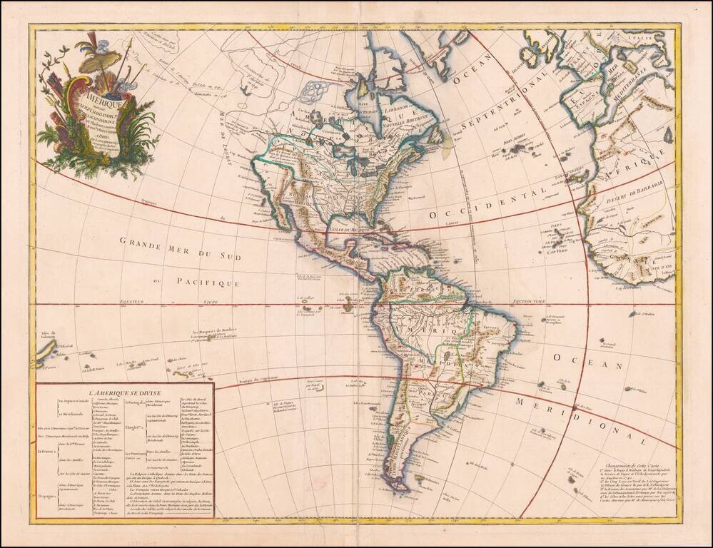
An Early Sea of the West, with Contributions from Charlevoix and Condamine
The first map to show Behring's discoveries along in Alaska and the Northwest Coast and a prototype map for the subsequent Buache, De L'Ise, Jefferys debate of the 1750s.
The routes and discoveries of Tchirikow in 1741 and 1742 are shown. No mention of Aguilar or De Fuca, but there are clearly tentative passages from the Pacific to Hudson's Bay and via a river system to the Great Lakes. The English Discoveries of 1742 along the western coast of Hudson's Bay are also shown. A continuous waterway from the Gulf of Mexico, via the Mississippi and Lahontan's River of the West to the Pacific is shown.
A note discusses the country of Quivera and Teguayo and the Sioux des Prairies. Port Ste. Lucie is shown opposite the Channel Islands on the California coast. Classic De L'Isle Baja California configuration.
The Sea of the West is curiously floating off the Northwest Coast of America, with a fine depiction of Lahontan's Long River, here called "Riv de Louest".
George-Louis Le Rouge (1712-1790), though known for his work in Paris, was originally born Georg Ludwig of Hanover, Germany. He grew up and was educated in Hanover, after which he became a surveyor and military engineer. Around 1740, however, Le Rouge moved to Paris and set up shop as an engraver and publisher on the Rue des Grands Augustins. It was at this time that he changed his name, adopting a French pseudonym that would later become quite famous.
Le Rouge spent much of his forty-year career translating various works from English to French, and his cartographic influence often came from English maps. His experience as a surveyor and engineer in Germany made him a skilled and prolific cartographer, and he produced thousands of charts, maps, atlases, and plans. His work spans from garden views and small-town plans to huge, multiple-continent maps. Le Rouge eventually accepted the position of Geographical Engineer for Louid XV, the King of France.
Later in life, Le Rouge became well-known for publishing North American maps, such as in his Atlas ameriquain septentrional of 1778. One of Le Rouge’s other more famous works is the Franklin/Folger chart of the Gulf Stream, which he worked on with Benjamin Franklin. Franklin and Le Rouge corresponded around 1780 and collaborated to create this map, a French version of Franklin’s famous chart which was originally printed in 1769.
If you are a student, write to us in telegram: @antiquemaps and indicate what material you need and for what work you need a map in high detail. We are ready to provide material on special terms. For students only!


