Map size in jpg-format: 13.9901MiB
Click to open in high resolution (open in new tab).

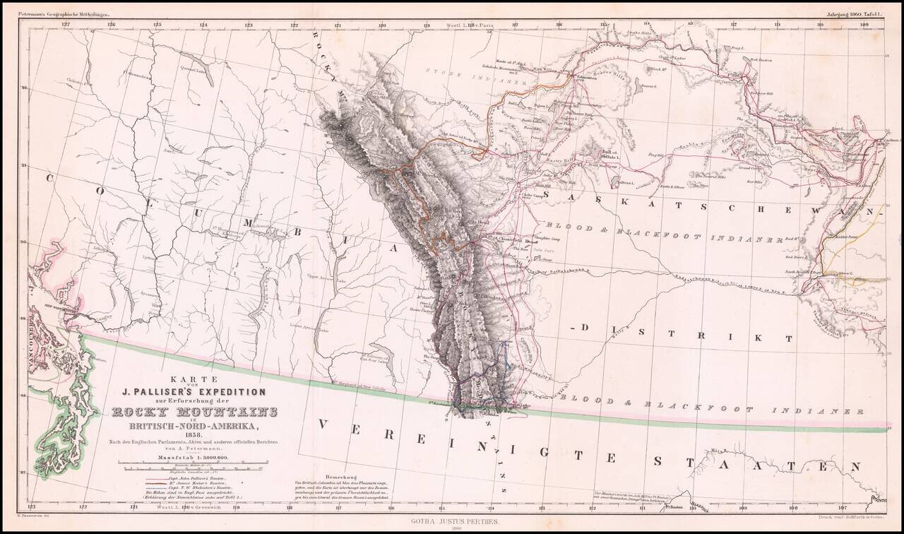
Detailed map of Western Canada illustrating the western part of Captain John Palliser's explorations in Western Canada, based upon Palliser's virtually unobtainable map published about three years earlier.
The map shows the disputed boundary claim vicinity of the San Juan Islands and the route of Palliser. engraved with mountains shown via hachure. Engraved line and hand coloring delineates the routes of Capt. John Palliser, Dr. James Hector, and Capt. T.W. Blakiston. Legend locates creeks, camps, portages, rapids, and more.
John Palliser (1817-1887) was born in Dublin. From 1839 to 1863, Pallisher served in the Waterford Militia, attaining the rank of Captain. He travelled to North America and participated in a hunting expedition in 1847, which resulted in his publication of Solitary Rambles and Adventures of a Hunter in the Prairies, first published in 1853. He travelled to Rupert's Land as leader of the British North American Exploring Expedition, which travelled over the uncharted regions of the far west between 1857 and 1861. During this time, he created his map and made a topographical delimitation of the boundary between British North America and the United States, from Lake Superior to the coast of the Pacific Ocean. He was assisted by astronomer Lieutenant Thomas Blakiston of the Royal Artillery, botanist Eugene Bourgeau and geologist Dr James Hector.
He returned to Ireland in 1862 and presented his findings to the British Parliament. The information contained in his survey was instrumental in the ending of the Hudson's Bay Company's ownership of Rupert's Land (lands encompassing all tributaries to Hudson Bay) with the Deed of Surrender in 1869. While Palliser is credited with opening up a new era of settlement and development in the Canadian West, his warnings about the unsuitability to agricultural development of the area now known as Palliser's Triangle went unheeded. Palliser reported that the region, in southeastern Alberta and southwestern Saskatchewan, was too arid for farming. The Government ignored his report, with catastrophic results for those who attempted to settle the region.
If you are a student, write to us in telegram: @antiquemaps and indicate what material you need and for what work you need a map in high detail. We are ready to provide material on special terms. For students only!

![Amer. Sep. No. 33. Partie De La Nouvelle Bretagne (Upper Missouri River, Lake Winnepeg, Lake of the Woods and Saskatehawan River]](/map/small/41687.jpg)
