logo

1899. Kaart van Suriname Naar De opmetingen Van J.F.A. Cateau Van Rosevelt en J.F.A.E. Van Lansberge, Aangevuld tot 1898 Met Die Van - En Geteekend Door W. L. Loth

  • Kaart van Suriname Naar De opmetingen Van J.F.A. Cateau Van Rosevelt en J.F.A.E. Van Lansberge, Aangevuld tot 1898 Met Die Van - En Geteekend Door W. L. Loth
  • Kaart van Suriname Naar De opmetingen Van J.F.A. Cateau Van Rosevelt en J.F.A.E. Van Lansberge, Aangevuld tot 1898 Met Die Van - En Geteekend Door W. L. Loth

Kaart van Suriname Naar De opmetingen Van J.F.A. Cateau Van Rosevelt en J.F.A.E. Van Lansberge, Aangevuld tot 1898 Met Die Van - En Geteekend Door W. L. Loth information:

Year of creation: 
Resolution size (pixels): 
 25917x27751 px
Disk Size: 
 138.188MiB
Number of pages: 
 2
Place: 
 Amsterdam

Print information. Print size (Width x height in inches):
Printing at 72 dpi 
  359.96 х 385.43
Printing at 150 dpi 
 172.78 х 185.01
Printing at 300 dpi 
 86.39 х 92.5

An example of detailing the file of this map of in a printable high-resolution:

Click to open in high resolution (open in new tab).
Attention! this is just the central piece (central area 960x960 px) of the map file!
This is an example, so that you can see and study the level of detail of a given map. The entire Map will be fully available after payment!

Kaart van Suriname Naar De opmetingen Van J.F.A. Cateau Van Rosevelt en J.F.A.E. Van Lansberge, Aangevuld tot 1898 Met Die Van - En Geteekend Door W. L. Loth

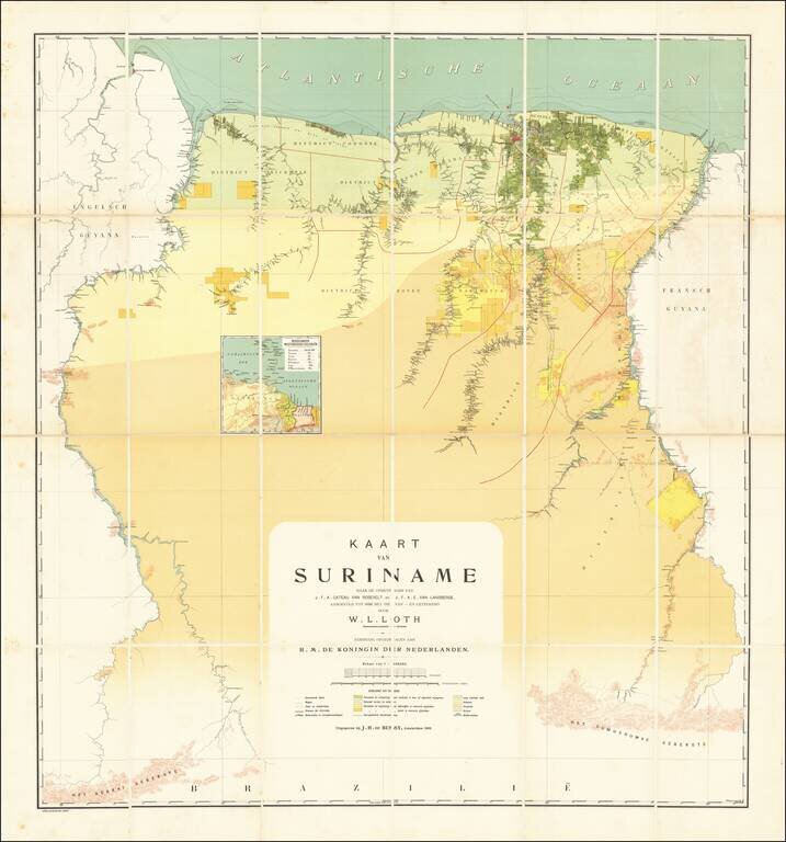
The First Modern Map of Suriname

Fine example of W. L. Loth'a large map, generally regarded as the first 'modern' map of Suriname.

The vast majority of information depicted on the map appears along the major Rivers in the interior of the country, with very little detail shown in the southern reaches.

Loth drew on the surveys of Johan François Adriaan Cateau van Rosevelt and L.C. van Lansberge undertaken between 1860 and 1879, but added significant new information, most notably the depiction of the New River as the continuation of the Corentyne River.

The map depicts Suriname at a time when its borders were still very much in dispute with its British, French and Brazilian neighbors.


Special conditions for students!

If you are a student, write to us in telegram: @antiquemaps and indicate what material you need and for what work you need a map in high detail. We are ready to provide material on special terms. For students only!

Item information:

Year of creation:
Size:
25917x27751 px
Disk:
138.188MiB
Number of pages:
2
Place:
Amsterdam
$21.99

Related item