Map size in jpg-format: 22667600B
Click to open in high resolution (open in new tab).
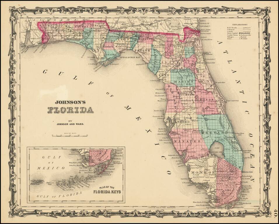
Fine early map of Florida, hand colored by county, with a large inset of the Florida Keys.
Shows towns, railroads, villages, post offices, forts, swamps,
Only 5 counties shown in the southern part of Florida, including Dade, Monroe, Brevard, Manatee and Hillsboro. Early appearance of Miami. Indian Hunting grounds noted in between Ft. Poinsett and Key Biscayne Bay. Many early forts appear. The GLO surveys are note yet complete in the Everglades and elsewhere.
From an early edition of Johnson's Family Illustrated Atlas, one of the most popular American Atlases in the second half of the 19th Century.
Benjamin P. Ward was an American publisher. He was best known for his partnership with A. J. Johnson. In 1860, the Johnson firm published its first significant work, the Johnson’s New Illustrated (Steel Plate) Family Atlas. The first edition of the Atlas bears imprints in both New York and Richmond, VA. In 1861, however, following the outbreak of the American Civil War, the Johnson & Browning firm abandoned their Richmond location. Browning seems to have remained in Virginia to pursue other ventures and, in 1861, Browning’s portion of the firm was purchased by Ward. The 1863 issue of the Atlas was one of the most unusual, it being a compilation of older Johnson and Browning maps, updated 1862 Johnson and Ward maps, and newer 1863 maps with a revised border design. The 1864 issue of the Atlas is the first true Johnson and Ward atlas. Johnson published one more edition in partnership with Ward in 1865, after which Johnson becomes the sole publisher.
If you are a student, write to us in telegram: @antiquemaps and indicate what material you need and for what work you need a map in high detail. We are ready to provide material on special terms. For students only!

![[Wall Map] West-Indische Paskaert waer in de graden der breedde over weder zyden vande middelyn wassende so vergrooten dat die geproportioneert syn tegen hunne nevenstaende graden de lengde.](/map/small/60169.jpg)
