Map size in jpg-format: 1.07MiB
Click to open in high resolution (open in new tab).
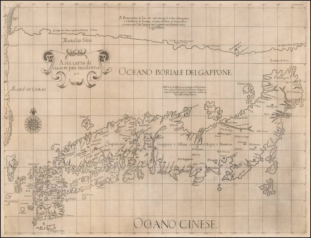
The Map of Japan Based Upon The Jesuit Maps of Inacio Moreira and Christopher Blancus
Fine example of the first state of Robert Dudley's rare map of Japan, first published in 1646.
This is one of the two maps of Japan created by Dudley for his Dell' Arcano del Mare. The second map includes Korea and a portion of the Chinese coast .
The map is based upon the maps of Blancus and Moreira, but adds a huge 'Jesso' filling the top of this old map. The map is of interest for the use of East Sea, the sea between Korea and Japan, here called "Mare di Corai". Dudley names the sea north of Japan "Oceano Boriale del Giappone", and the waters directly east of the Korean coast "Mare di Corai". The first time that the disputed designation appears is on Matteo Ricci's Chinese world map of 1602. The place names follow Ginnaro, though he invented numerous additional imaginative names.
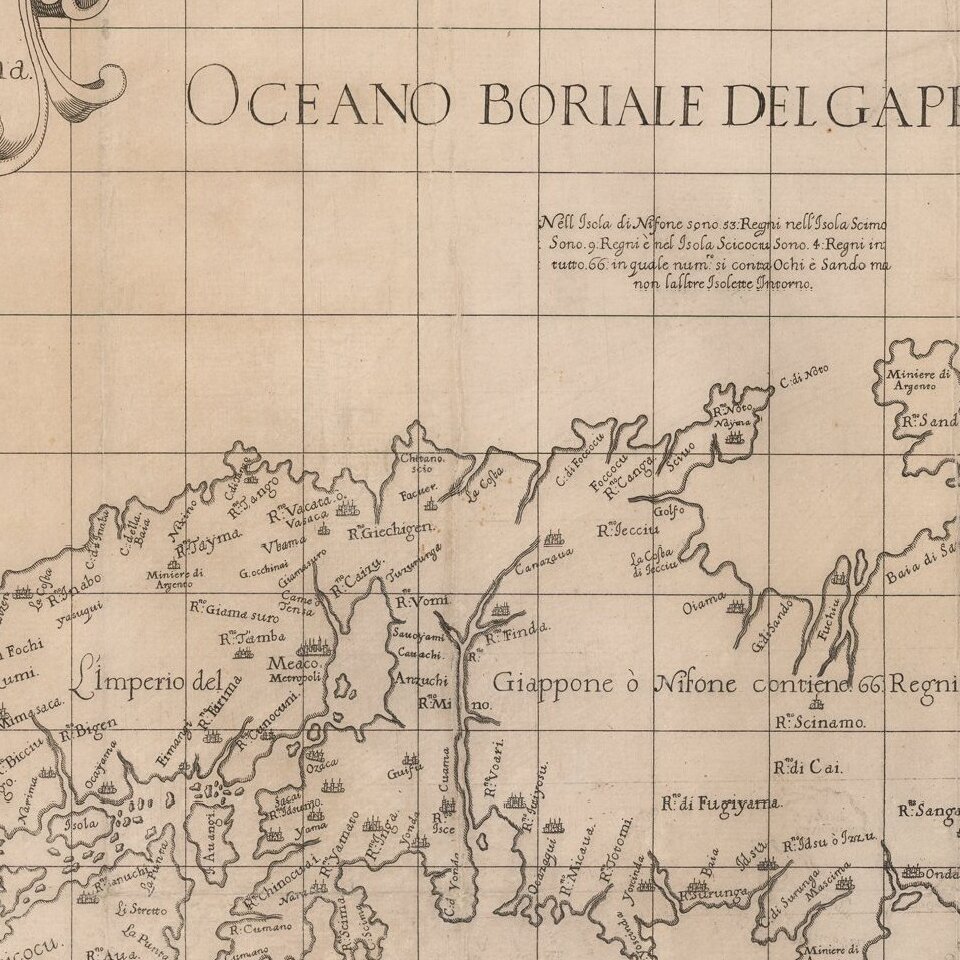
Blancus / Moreira Mapping of Japan
The information contained in the map derives from the rich Jesuit history of studying the geography and political borders of Japan and its 66 daimyo domains. A number of manuscript maps reflecting the growing knowledge of the Jesuits were brought back to Europe during the 16th Century and over time began to appear in printed maps in the West.
Perhaps the most significant of the early Jesuit maps was the map of the Portuguese mapmaker Inacio Moreira, who was resident in Japan from 1590-98 and was able to compile significant information during his stay. In 1590, he traveled to Nagasaki with Allesandro Valignano, who was returning from Europe with a Japanese diplomatic contingent who had visited Rome. Moreria surveyed Japan from Kyushu to Kyoto, adding significant local information provided by Japanese informants. He was also able to determine the length of the Japanese ri (distance measurement) and convert it to Spanish and Portuguese measurements, allowing him to create the first scientifically accurate map of Japan.
While Moreira's original map is now lost, a description of the map survived in Valignanos' written description of the map which appeared in his Libro primero del principio y progresso de la religion Christiana en Jappon . . . . From this description, modern scholar Jason Hubbard was able to determine that a map engraved in Rome, in 1617, by Christophorus Blancus (Rome, 1617) (also lost, but known in a later copy of the map), was in fact a direct copy of Moreira's lost map.
While the Blancus map is now virtually lost, it was copied by several contemporary mapmakers, including the maps made by Jesuit map makers Bernardino Ginnaro and Antonio Cardim, and by English chart maker Robert Dudley, whose depictions of the map have provided the most widely disseminated and enduring evidence of this fascinating chapter of the cartographic history of Japan.
This sea chart appeared in Robert Dudley's Dell'Arcano del Mare, one of the rarest and most highly sought after sea atlases of the 17th Century. Robert Dudley, an Englishman, produced this exquisite work while living in Florence. Dudley, who was believed to have received some of his information directly from Sir Francis Drake, labored for decades before finally releasing the first edition of this work when he was 73 years old. Dudley's atlas is of the utmost importance, being the first Sea Atlas published by and Englishman and the first Sea Atlas to treat the entire world (not just Europe). It is also the first atlas to utilize the Mercator Projection on a uniform basis and included significant advances in "Great Circle" navigation (shortest circle around the Globe). Its inclusion of winds and currents was also a monumental first. Completed in Manuscript form in 1636, it is among the most important works in the history of European Cartography.
Robert Dudley (1574 - 1649) was the illegitimate son of Robert Dudley, 1st Earl of Leicester. In 1594, Dudley led an expedition to the West Indies, of which he wrote an account. In 1605, he tried unsuccessfully to establish his legitimacy in court. After that he left England and converted to Catholicism, taking up residence in Florence, where he served the Grand Dukes of Tuscany, in their efforts to rid the Mediterranean of Piracy. There he worked as a noted shipbuilder and designed and published Dell'Arcano del Mare, the first maritime atlas to cover the whole world. He was also a skilled navigator, mathematician and engineer. In Italy, he styled himself Earl of Warwick and Leicester, as well as Duke of Northumberland. He was a friend of Sir Francis Drake and relative of Thomas Cavendish, both of whom corresponded with Dudley and likely supplied some of the information for his Atlas.
If you are a student, write to us in telegram: @antiquemaps and indicate what material you need and for what work you need a map in high detail. We are ready to provide material on special terms. For students only!
![[First Map of the American Continent] Tavola dell' isole nuove, le quali son nominate occidentali, & indiane per diversi rispetti.](/map/small/67312.jpg)

![[English Edition!] Maris Pacifici quod vulgo Mar del Zud](/map/small/71000.jpg)