logo

1695. Iudaea seu Terra Sancta Quae Hebraeorum sive Israelitarum in suas duodecim Tribus divisa secretis ab invicem Regnis Iuda et Israel expressis insuper sex ultimi temporis ejusdem Terrae Provincijs . . .

  • Iudaea seu Terra Sancta Quae Hebraeorum sive Israelitarum in suas duodecim Tribus divisa secretis ab invicem Regnis Iuda et Israel expressis insuper sex ultimi temporis ejusdem Terrae Provincijs . . .

Iudaea seu Terra Sancta Quae Hebraeorum sive Israelitarum in suas duodecim Tribus divisa secretis ab invicem Regnis Iuda et Israel expressis insuper sex ultimi temporis ejusdem Terrae Provincijs . . . information:

Year of creation: 
Resolution size (pixels): 
 14328x12061 px
Disk Size: 
 30.8893MiB
Number of pages: 
 1
Place: 
 Amsterdam
Author: 

Print information. Print size (Width x height in inches):
Printing at 72 dpi 
  199 х 167.51
Printing at 150 dpi 
 95.52 х 80.41
Printing at 300 dpi 
 47.76 х 40.2

An example of detailing the file of this map of in a printable high-resolution:

Click to open in high resolution (open in new tab).
Attention! this is just the central piece (central area 960x960 px) of the map file!
This is an example, so that you can see and study the level of detail of a given map. The entire Map will be fully available after payment!

Iudaea seu Terra Sancta Quae Hebraeorum sive Israelitarum in suas duodecim Tribus divisa secretis ab invicem Regnis Iuda et Israel expressis insuper sex ultimi temporis ejusdem Terrae Provincijs . . .

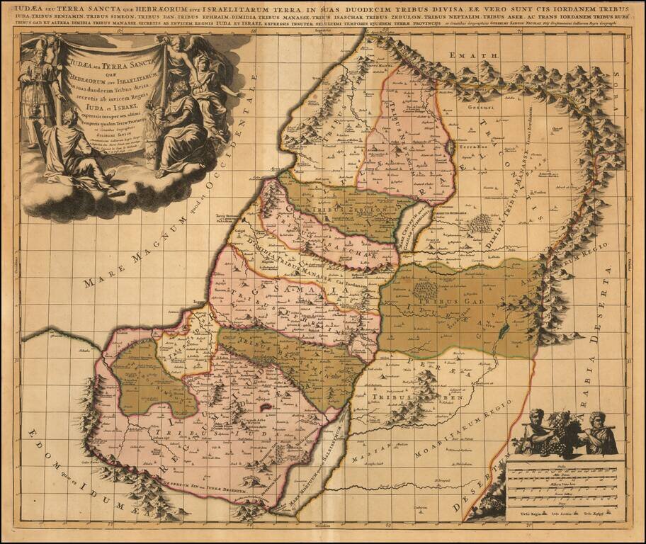
Old color example of Schenk's map of the Holy Land, showing the 12 Tribes of Israel.

Includes a finely engraved allegorical cartouche.

Peter Schenk the Elder (1660-1711) moved to Amsterdam in 1675 and began to learn the art of mezzotint. In 1694 he bought some of the copperplate stock of the mapmaker Johannes Janssonius, which allowed him to specialize in the engraving and printing of maps and prints. He split his time between his Amsterdam shop and Leipzig and also sold a considerable volume of materials to London.

Peter Schenk the Elder had three sons. Peter the Younger carried on his father’s business in Leipzig while the other two, Leonard and Jan, worked in Amsterdam. Leonard engraved several maps and also carried on his father’s relationship with engraving plates for the Amsterdam edition of the Histoire de l'Académie Royale des Sciences.  


Special conditions for students!

If you are a student, write to us in telegram: @antiquemaps and indicate what material you need and for what work you need a map in high detail. We are ready to provide material on special terms. For students only!

Item information:

Year of creation:
Size:
14328x12061 px
Disk:
30.8893MiB
Number of pages:
1
Place:
Amsterdam
Author:
Peter Schenk.
$14.99

Related item