logo

1782. Island of St. Lucia / Island of St. Vincent / Island of Barbados / Chart of Part of the Windward Is. . . .

  • Island of St. Lucia / Island of St. Vincent / Island of Barbados / Chart of Part of the Windward Is. . . .

Island of St. Lucia / Island of St. Vincent / Island of Barbados / Chart of Part of the Windward Is. . . . information:

Year of creation: 
Resolution size (pixels): 
 4859x6188 px
Disk Size: 
 7.66713MiB
Number of pages: 
 1
Place: 
 London
Author: 

Print information. Print size (Width x height in inches):
Printing at 72 dpi 
  67.49 х 85.94
Printing at 150 dpi 
 32.39 х 41.25
Printing at 300 dpi 
 16.2 х 20.63

An example of detailing the file of this map of in a printable high-resolution:

Click to open in high resolution (open in new tab).
Attention! this is just the central piece (central area 960x960 px) of the map file!
This is an example, so that you can see and study the level of detail of a given map. The entire Map will be fully available after payment!

Island of St. Lucia / Island of St. Vincent / Island of Barbados / Chart of Part of the Windward Is. . . .

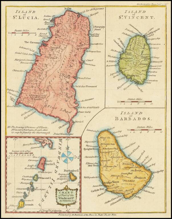
Interesting map of St. Lucia, St. Vincent, Barbados and the Windward Islands, published in the London Magazine.


Special conditions for students!

If you are a student, write to us in telegram: @antiquemaps and indicate what material you need and for what work you need a map in high detail. We are ready to provide material on special terms. For students only!

Item information:

Year of creation:
Size:
4859x6188 px
Disk:
7.66713MiB
Number of pages:
1
Place:
London
Author:
London Magazine.
$14.99

Related item