Map size in jpg-format: 9.94086MiB
Click to open in high resolution (open in new tab).
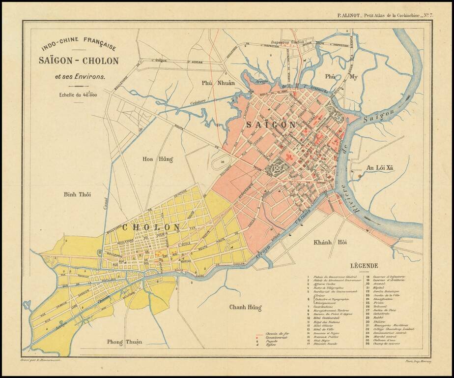
Finely executed plan of Saigon, today known as Ho Chi Minh City, on the eve of renowned French architect Ernest Hébrard's grand revisions to Saigon's urban landscape in the early 1920s.
The map appeared in the Petit Atlas de la Cochinchine
The map shows a European style colonial urban plan, including gardens, parks, wide boulevards and other public spaces, constructed along the banks of the Saigon River and situated between two smaller rivers, Arroyo de l’Avalanche and Arroyo Chinois.
This plan is centered on the original railway station built in 1885, with a large public gardens complex situated to the north. The streets include European names, including a street named for Lord Kitchner and several streets named after various colonels and admirals.
The town of Cholon is prominently shown at the southwest corner. Cholon was established by the ethnically Chinese Hoa community, and attracted further Chinese immigration. Originally 11km from Saigon, Cholon experienced rapid growth during this time this map was published and was incorporated into Saigon in 1931. The surrounding province, Giadinh, is also prominently marked and the villages outside of Saigon are noted below the province and canton names.
French Saigon
Although French trading occurred in the region beginning in the seventeenth century, the French were not heavily involved in Vietnam until the close of the eighteenth century. In 1789, French forces under Pigneau de Béhaine helped establish the Nguyen Dynasty, marking the beginning of French and imperial Vietnamese military collaborations until the 1820 death of the Emperor Gia Long. The successor, Emperor Minh Mang, was not receptive to French contact and established an anti-Catholic, anti-missionary policy, persecuting French missionaries in the country.
By the middle of the nineteenth century, Napoleon III began negotiating with the Vietnamese imperial court, recalling his troops in exchange for greater commercial and religious freedoms for France’s merchants and missionaries. In 1859, the French invaded under the command of Admiral Rigault de Genouilly, finally capturing and destroying Saigon two years later in 1861.
Following the signing of the 1862 Treaty of Saigon, France solidified and reinforced its initial foothold on the Indochinese Peninsula. Under the terms of the agreement, the French received Saigon, the island of Poulo Condor, and three southern provinces (Bien Hoa, Gia Dinh, and Dinh Tuong), naming the area Cochinchina. The treaty also stipulated opening ports to trade, freedom to conduct missionary activity, a vague protectorate roll in Vietnam’s foreign relations, and a large cash indemnity.
In 1864, these terms were again formally recognized by the second Treaty of Saigon. French Indochina was officially formed in October 1887 from Annam, Tonkin, Cochinchina (all of modern Vietnam) and Cambodia, following the Sino-French war (1884–1885).
The 1860s mark the beginning of the transformation of Saigon from a settlement dominated by wooden buildings to a prominent port city of paved boulevards, sidewalks and colonial architecture. As the capital of French Indochina until 1902, serious redevelopment was concentrated in Saigon. The French continued to finance grand public spaces, building riverfront promenades, quays, and large sidewalks, and hiring planners to develop a European-style city.
In 1923, Governor-General Maurice Long created the Urbanism Department of Indochina and appointed Ernest Hébrard as Director. Hébrard was a professional urbanist, and he created plans for all of Indochina’s major cities. He is credited with creating a syncretic style that incorporated Indochinese art elements into traditional French colonialist architecture.
This map heralds the beginning of a profound shift in Saigon’s urban landscape, created just prior to Ernest Hébrard’s era as head architect. It is beautifully-executed city plan and a fascinating glimpse into the French colonial reworkings of Saigon.
If you are a student, write to us in telegram: @antiquemaps and indicate what material you need and for what work you need a map in high detail. We are ready to provide material on special terms. For students only!
![[Signed Political Satire Artwork] Vietnam ... Vietnam ... Vietnam ...](/map/small/68726.jpg)

