Map size in jpg-format: 38.5629MiB
Click to open in high resolution (open in new tab).
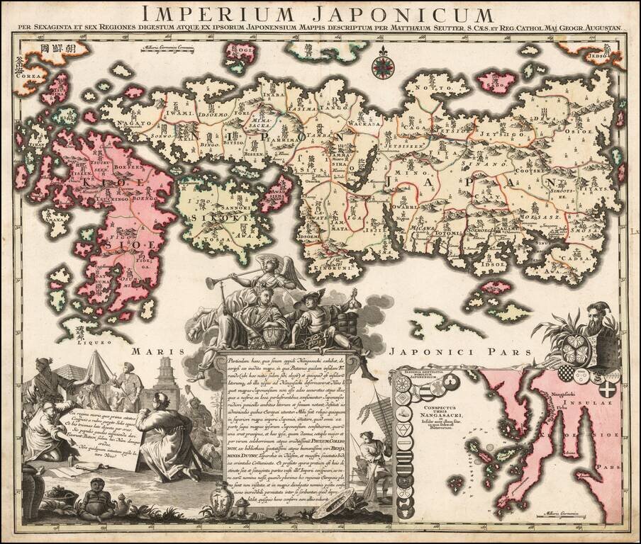
Nice example of Matthaus Seutter's edition of Adrien Reland's seminal map of Japan.
Adrien Reland's map of Japan is the first map to use Sino-Japanese characters on a European printed map and represents a radical departure from prior European maps of Japan.
Instead of following prior European maps and geographical sources, Reland utilized Japanese maps, most notably a map from the library or Benjamin Dutry, a former director of the Dutch VOC (East India Company). In some respects, this represented a tremendous leap forward in the geographical depiction of Japan, such as in the treatment of Kyushu and in naming the 66 provinces.
The map first appeared in 1715 in volume 3 of Jean Frederic Benard's Recuiel de voiages, and was thereafter copied by several other European mapmakers and became the primary means of mapping Japan during the period.
Includes a large inset of the area around Nagasaki, the location of an island which at the time was the only place where Westerners were allowed to trade with Japan.
Ornate dedication cartouche, with about 20 coats of arms.
If you are a student, write to us in telegram: @antiquemaps and indicate what material you need and for what work you need a map in high detail. We are ready to provide material on special terms. For students only!
![[First Map of the American Continent] Tavola dell' isole nuove, le quali son nominate occidentali, & indiane per diversi rispetti.](/map/small/67312.jpg)

![[English Edition!] Maris Pacifici quod vulgo Mar del Zud](/map/small/71000.jpg)