Map size in jpg-format: 24.1439MiB
Click to open in high resolution (open in new tab).
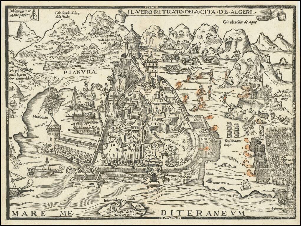
Rare Early Map of the Holy Roman Empire's Siege of Algiers in 1541
The only known example of Matteo Pagano's Map of the 1541 Conquest of Tunis, engraved in Venice by the master engraver Matteo Pagano.
This rare and until recently unknown woodcut map was first catalogued by Szathmáry (1992) who in 1987 bought the only known example of this work in Arezzo. The work was part of a small collection of woodcut plates signed by Matteo Pagano, Giovanni Andrea Vavassore and Tommaso di Salò, which were then sold separately. After that the work was part of the Fritz Hellwig collection. Szathmáry, in the cataloging of these unpublished works woodcuts, dated the map to 1541, probably based on the military events depicted in the table, relating to the siege of Algiers in 1541, by the fleet led by Charles V. However, if we accept the hypothesis that the model of this work is the De stadt van Aelgier (1542) by Cornelis Antoniszoon, the work of Pagano must necessarily be later. The other theory, that this plate is the model for the Dutch one, seems to be disproved by the fact that Antoniszoon took part in the expedition of Charles V to the African coast.
Antoninzoon Plan: https://commons.wikimedia.org/wiki/Category:Cornelis_Anthonisz.#/media/File:Beleg_van_Algiers_1541.png
The Algiers Expedition
The 1541 Algiers expedition occurred when Charles V of the Holy Roman Empire attempted to lead an amphibious attack against the Ottoman Empire's stronghold of Algiers, in modern Algeria. Inadequate planning, particularly against unfavourable weather, led to the failure of the expedition.
Algiers had been under the control of the Ottoman Emperor Suleiman the Magnificent since its capture in 1529 by Barbarossa. Barbarossa had left Algiers in 1535 to be named High Admiral of the Ottoman Empire in Constantinople, and was replaced as governor by Hassan Agha, a eunuch and Sardinian renegade. Hassan had in his service the well-known Ottoman naval commanders Dragut, Sālih Reïs, and Sinān Pasha.
Charles V made considerable preparations for the expedition, wishing to obtain revenge for the recent siege of Buda. However the Spanish and Genoese fleets were severely damaged by a storm, forcing him to abandon the venture. The Expedition began in late September 1541, delayed by troubles in Germany and Flanders. The fleet was assembled in the Bay of Palma, at Majorca. It had more than 500 sails and 24,000 soldiers. After enduring difficult weather, the fleet only arrived off the coast of Algiers on October 19. The most distinguished Spanish commanders accompanied Charles V on this expedition, including Hernán Cortés, the conqueror of Mexico, though he was never invited to the War Council.
Charles established his headquarters on a land promontory surrounded by German troops. German, Spanish, and Italian troops, accompanied by 150 Knights of Malta, began to land while repelling Algerine opposition, soon surrounding the city, except for the northern part. The fate of the city seemed to be sealed, however the following day the weather became severe with heavy rains. Many galleys lost their anchors and 15 were wrecked onshore. Another 33 carracks sank, while many more were dispersed. As more troops were attempting to land, the Algerines started to make sorties, slaughtering the newly arrived. Charles V was surrounded, and was only saved by the resistance of the Knights of Malta.
Andrea Doria managed to find a safer harbor for the remainder of the fleet at Cape Matifu, 5 miles east of Algiers. He enjoined Charles V to abandon his position and join him in Matifu, which Charles V did with great difficulty. From there, still oppressed by the weather, the remaining troops sailed to Bougie, still a Spanish harbor at that time. Charles abandoned his army and sailed home.
Rarity
This is the only known example, as previously documented by Bifolco-Ronca. All Matteo Pagano separately published maps are of the utmost rarity.
Provenance: Fritz Hellwig collection, purchased at Reiss & Sohn in 2019.
If you are a student, write to us in telegram: @antiquemaps and indicate what material you need and for what work you need a map in high detail. We are ready to provide material on special terms. For students only!


![The West Part of Barbary... [on sheet with:] The East Part of Barbary...](/map/small/52496.jpg)