Map size in jpg-format: 42.3844MiB
Click to open in high resolution (open in new tab).
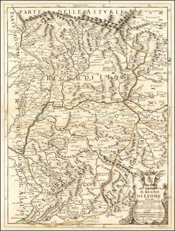
Antique engraved map of part of the Spanish region of Asturias, published by Giacomo and Domenico de Rossi in their Mercurio Geografico in Rome in 1696.
The cartouche at the lower right aptly features the Leonese coat of arms with a rampant lion.
The Kingdom of León was incorporated into the Crown of Castile in 1230.
Giacomo Giovanni Rossi (1627-1691) was an Italian engraver and printer. He worked in Rome, the heir to an important printing business founded by his father, Giuseppe de Rossi (1570-1639). Giuseppe began the press in 1633 and Giovanni and his brother, Giandomenico (1619-1653) took it over upon his death. The brothers expanded the business and by the mid-seventeenth century it was the best-known printing house in Rome.
For his maps, Giovanni worked with Giacomo Cantelli da Vignola. They produced the Atlas Mercurio Geografico. The first edition is undated, but the second was issued in 1692, a year after Giovanni’s death. The maps were by Cantelli. The firm also published maps based on those of Nicolas Sanson.
Later, the business passed to Lorenzo Filippo (1682-?). By 1738, the firm was known as Calcografia Camerale, then, from 1870 to 1945, as the Regia Calcografica. Today, the firm is still in business and is called Calcografia Nazionale. It operates as a free museum and offers one of the best collections of prints and plates in the world.
If you are a student, write to us in telegram: @antiquemaps and indicate what material you need and for what work you need a map in high detail. We are ready to provide material on special terms. For students only!
![(Pro-Spanish Republic Political Broadside) [Lift The Embargo Against The Spanish Republic] President Roosevelt says . . .](/map/small/50218.jpg)

