Map size in jpg-format: 1006.68KiB
Click to open in high resolution (open in new tab).

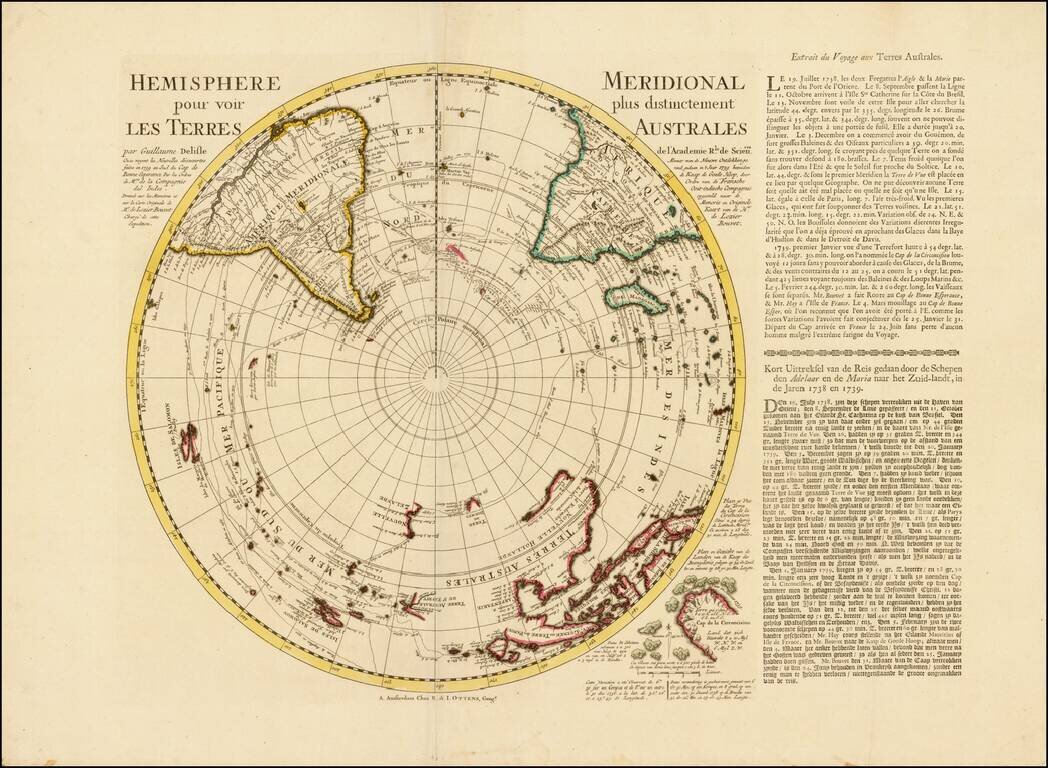
A Rare Ottens map of the Southern Hemisphere, with an additional text panels
Southern Hemisphere
This fascinating map captures the entire Southern Hemisphere from a polar projection. This rare variant example includes an additional text panel describing Lozier Bouvet's voyage, added to the right side of the map. The cartography features many of the contemporary myths and anomalies associated with the Antipodes. The map features excellent projections of Australia and New Zealand, along with a number of early routes of exploration from the 16th, 17th and 18th Centuries, including Tasman, Halley, Damiper, Magellan, Le Maire, Mendana and others.
The "port", allegedly discovered by Sir Francis Drake, otherwise known as Drake's Island, in 1577, lies to the southwest of Cape Horn. Some of the more notable features are Edmund Halley's sighting of Antarctic ice; Bouvet's large Cap de la Circoncision; Carpentaria attached to New Guinea; Tasman's route, along with a depiction of Tasmania as per Tasman, distinctly separate from Australia.
Emphasized on the map (heightened in orange) is the route of the 1738-9 voyage of Jean-Baptiste Charles Bouvet de Lozier (1705-86), commanding the ships Aigle and Marie, undertaken at the behest of the French East India Company. Bouvet's mandate was to find the apocryphal great southern continent. The text mentions Bouvet's discovery of icebergs between two and three hundred feet high and half a league to two or three leagues in circumference. On January 1, 1739, Bouvet encountered an icy promontory, which he named Cap de la Circoncision, at 54° South, below Africa, supposedly located next to one of the openings of his polar sea, where he had recorded his many great icebergs. An inset in the lower right of the map details this discovery.
Importantly, this was the first time land had been spotted beyond the 50th parallel South in the Eastern Atlantic. Bouvet, spotted Cap Circoncision, but severe fog and ice ensured that he was unable to explore the area further, and thus he was unaware that the landmass was part of an island, and not a southern continent. Bouvet lost sight of the cape and was unable to relocate it in the days that followed. For many decades after this map was printed, it remained a mystery as to the true nature of this discovery. Bouvet's plotting of his course was inaccurate, and in spite of several attempts, the cape was not encountered again until 1808, when it was proven to be an island. Named Bouvet Island, it is one of the World's most isolated points of land, very distant from both Africa and Antarctica, and is today administered by Norway.
A fine example of the maps.
If you are a student, write to us in telegram: @antiquemaps and indicate what material you need and for what work you need a map in high detail. We are ready to provide material on special terms. For students only!
![[Eastern Hemisphere Globe Gores] (Nova et integra universi Orbis descriptio)](/map/small/54480.jpg)

