Map size in jpg-format: 55.046MiB
Click to open in high resolution (open in new tab).
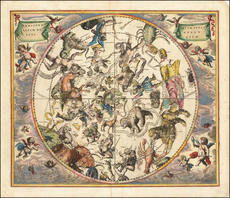
Very nice example of this striking chart of the Northern Sky, illustrating the constellations of the Northern Hemisphere superimposed over the earth's Southern Hemisphere, from Andreas Cellarius's Harmonia Macrocosmica, first published in 1660.
The map provides a fantastic image of the stars, as if seen from deeper in space, so that each of the constellations is facing in the opposite direction from the way that the same constellations would be seen from earth.
This projection reflects a theory that originated with Petrus Plancius that the stars remained in a sphere-like configuration above the earth, which moved in coordination with the earth. This theory is found in the title of his atlas, Harmonia Macrocosmica.
Andreas Cellarius was born in 1596 in Neuhausen and educated in Heidelberg. He emigrated to Holland in the early 17th century, and in 1637 moved to Hoorn, where he became the rector of the Latin School. Cellarius' best-known work is his Harmonia Macrocosmica, first issued in 1660 by Jan Jansson, as a supplement to Jansson's Atlas Novus. The work consists of a series of Celestial Charts begun by Cellarius in 1647 and intended as part of a two-volume treatise on cosmography, which was never issued.
Cellarius' charts are the most sought after of celestial charts, blending the striking imagery of the golden age of Dutch Cartography with contemporary scientific knowledge. The present examples come from the Valk & Schenk edition of Cellarius' atlas, which is unchanged from the 1661 edition. The 1660 and 1661 editions can be distinguished by the inclusion of a plate number in the lower right corner of the 1661 edition. The Valk & Schenk edition can be distinguished by the addition of the printer's name (Valk & Schenk) in the titles of the maps.
If you are a student, write to us in telegram: @antiquemaps and indicate what material you need and for what work you need a map in high detail. We are ready to provide material on special terms. For students only!