Map size in jpg-format: 33.8059MiB
Click to open in high resolution (open in new tab).
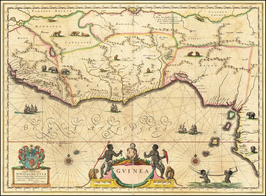
Fine Map of the Guinea Coast Included in Blaeu’s Famous Atlas and Including the Famous Apes of Dr. Tulp
Detailed map of Guinea, showing the length of a coast important to African-European trade, including the slave trade. Originally drawn by Willem Blaeu in ca. 1635, it was later included by his son, Joan, in the latter’s magisterial Atlas Maior, first published in 1662.
The map shows the African coast from Sierra Leone in West Africa to Biafara. As with all European maps of Africa of the mid-seventeenth century, the coastline is much more detailed than the interior, reflecting the state of geographic knowledge about the continent.
Many mountain chains run through the center of the various kingdoms, while settlements are marked with small building symbols that increase in size according to the city’s population or fame. The main geographic feature is the large river running parallel to the top border, the Niger. An inscription near the river explains its dark color and lifegiving qualities in a dry region, like the Nile farther east.
As on Blaeu’s map of the entire continent, seen here, animals roam freely over the interior. Two crocodiles prowl near the Niger, while lions range farther south. Small herds of elephants are in the southwest and southeast, while monkeys explore Guinea. At sea, two compass roses radiate rhumb lines and five ships sail the waters. In the bottom right, two young cherubs carry an elephant tusk aloft.
The apes of Dr Tulp
The more distinctive decorative elements of the map also carry the most interesting story. A coat of arms and a dedicatory cartouche in the lower left explain that the map is dedicated to Dr. Nicholas Tulp (1593-1674), a member of the Amsterdam government and a celebrated anatomist. The dedication is not meant as a hollow compliment, but as an ode to one of the most famous doctors of the seventeenth century. Tulp is the same doctor seen in Rembrandt’s The Anatomy Lesson (1632). In the painting, Tulp is surrounded by his colleagues who are eagerly watching as Tulp demonstrates the inner workings of a man’s forearm.
Rembrandt’s choice of an arm for the dissection is apt, as Tulp was particularly famous for his work on the anatomy of the arm. Specifically, Tulp had previously dissected the arm of an ape and found that its anatomy was almost the same as a human arm. The specimen was originally from Angola, just to the south of the area shown on this map. Tulp’s notes of the dissection are the earliest accurate description of an ape by a European, although specialists now believe he dissected a bonobo, not a chimpanzee as originally thought.
As a further reference to Dr. Tulp, detailed illustrations of three apes sit atop and on the sides of the title cartouche. The central ape is flanked by two African figures, a man holding beads and a spear, and a woman with beads and a parrot. These items and, sadly, the humans, represent the wealth available in the region depicted and also reflect the prevalence of the appalling slave trade then still in existence.
The maps were included in Blaeu atlases from 1635. Later, they became an important part of the famous Atlas Maior, the most beautiful atlas ever made and then the most expensive books ever produced. The maps of Africa made up roughly one half of volume 9 of the Atlas, sharing space with Spain and Portugal.
This is an exquisitely detailed map that tells an important chapter of the history of African-European exchange. As Blaeu’s maps were the most influential of the seventeenth century, it would have been an important map in its time and still is today.
If you are a student, write to us in telegram: @antiquemaps and indicate what material you need and for what work you need a map in high detail. We are ready to provide material on special terms. For students only!
![[Wall Map] West-Indische Paskaert waer in de graden der breedde over weder zyden vande middelyn wassende so vergrooten dat die geproportioneert syn tegen hunne nevenstaende graden de lengde.](/map/small/60169.jpg)
![[The First Maps in a la poupée Printed Color] Cartes en Couleur des Lieux Sujets aux tremblements de Terre Dans toutes les parties du Monde Selon le Sisteme de l’impulsion Solaire](/map/small/52293op.jpg)
