logo

1624. Gallo-Flandriae seu Castellaniarum Insulensis, Duacesis et Orchiacensis nova et accurata delineatio . . .

  • Gallo-Flandriae seu Castellaniarum Insulensis, Duacesis et Orchiacensis nova et accurata delineatio . . .

Gallo-Flandriae seu Castellaniarum Insulensis, Duacesis et Orchiacensis nova et accurata delineatio . . . information:

Year of creation: 
Resolution size (pixels): 
 10427x8523 px
Disk Size: 
 16.7396MiB
Number of pages: 
 1
Place: 
 Douai
Author: 

Print information. Print size (Width x height in inches):
Printing at 72 dpi 
  144.82 х 118.38
Printing at 150 dpi 
 69.51 х 56.82
Printing at 300 dpi 
 34.76 х 28.41

An example of detailing the file of this map of in a printable high-resolution:

Click to open in high resolution (open in new tab).
Attention! this is just the central piece (central area 960x960 px) of the map file!
This is an example, so that you can see and study the level of detail of a given map. The entire Map will be fully available after payment!

Gallo-Flandriae seu Castellaniarum Insulensis, Duacesis et Orchiacensis nova et accurata delineatio . . .

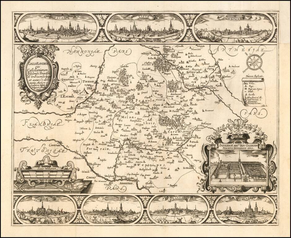
Rare regional map of French Flanders, with decorative views of the cities of Douai, Lille, Orchies, La Bassee, Armentières, Lannoy and Comines and the Jesuit College of Lille.

In 1627, Martin Le Bourgeois also published a large (35 x 31 inches) plan of Douai with 12 views of the colleges and 2 views of the city.

Rarity

The map is extremely rare, with OCLC locating only the examples at the Univerity of Leiden and Bibliotheque National de France.

Duvosquel, La région de Comines-Warneton, p.86 and p.92.

Special conditions for students!

If you are a student, write to us in telegram: @antiquemaps and indicate what material you need and for what work you need a map in high detail. We are ready to provide material on special terms. For students only!

Item information:

Year of creation:
Size:
10427x8523 px
Disk:
16.7396MiB
Number of pages:
1
Place:
Douai
Author:
Martin Le Bourgeois.
$14.99

Related item