Map size in jpg-format: 20.5936MiB
Click to open in high resolution (open in new tab).
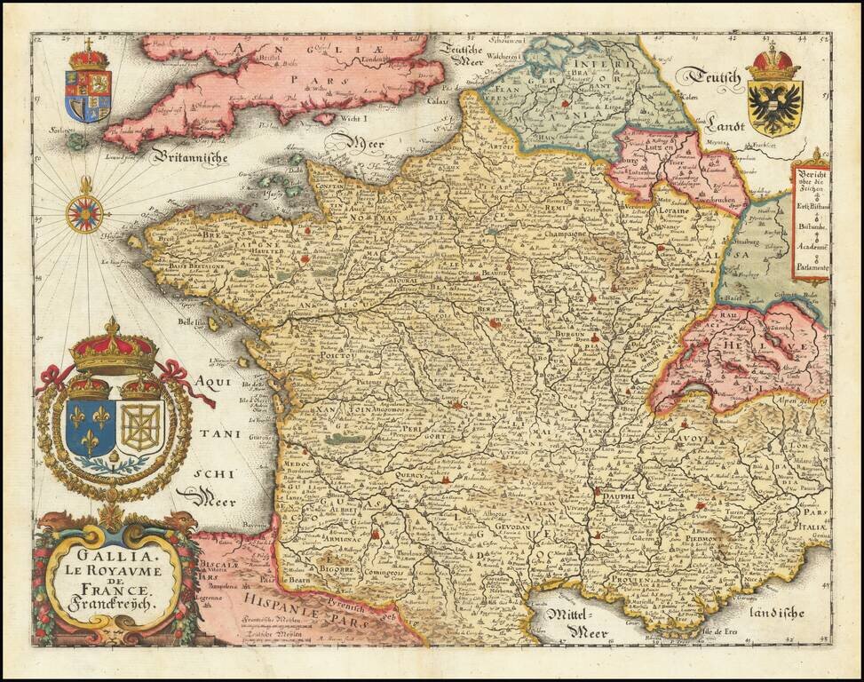
A striking full-color example of Merian's decorative map of France. The map includes a large cartouche, compass rose, and four coats of arms. The map is extensively and accurately detailed, typical of Merian's maps. Parts of adjoining countries are shown including Belgium, Luxembourg, England, Spain, and Switzerland.
What stands out the most on the map are the many rivers of the region. The five great rivers of France and their many branches are all easily traceable and named. Important cities, including Lyon and Rennes, are colored in red, though the choice of which cities got this treatment seems a bit random. Auch, Cahors, and Langres are all colored while Toulouse, Nice, and Bordeaux are uncolored. Paris is shown in green. Other features, such as forests and hills, are all shown in attractive pictorial style. Even bridges are shown and labeled.
The four coats of arms are all crested with crowns, representing the French monarchy. The Fleur de Lys in the bottom left is accompanied by an L, representing Louis XIII, the current ruler. The double-headed eagle signals that France was considered an empire at the time and the country's layout was indeed extensive, as shown in this map.
These features make for a very attractive mid-17th century map of France. The country is shown at one of its many peaks of power, and detail is abundant and relatively accurate for maps of the time.
Mathaus Merian (1593-1650) was the father of engraver Matthäus the Younger, and of the painter, engraver, and naturalist Maria Sibylla Merian. He was born in Basel, Switzerland and trained in engraving in Zurich. After a time in Nancy, Paris and Strasbourg, he settled in Frankfurt. While there, he worked for Johann Theodor de Bry, the publisher and son of the travel writer. In 1617, he married Maria Magdalena de Bry, Johann Theodor’s daughter. In 1623, Merian took over the de Bry publishing house upon the death of his father-in-law. Merian’s best known works are detailed town views which, due to their accuracy and artistry, form a valuable record of European urban life in the first half of the sixteenth century
If you are a student, write to us in telegram: @antiquemaps and indicate what material you need and for what work you need a map in high detail. We are ready to provide material on special terms. For students only!
![Carte d'Etude [Study Map]](/map/small/66795.jpg)
![Orange [Vauban Style Fortress]](/map/small/62043.jpg)
