Map size in jpg-format: 22.0611MiB
Click to open in high resolution (open in new tab).
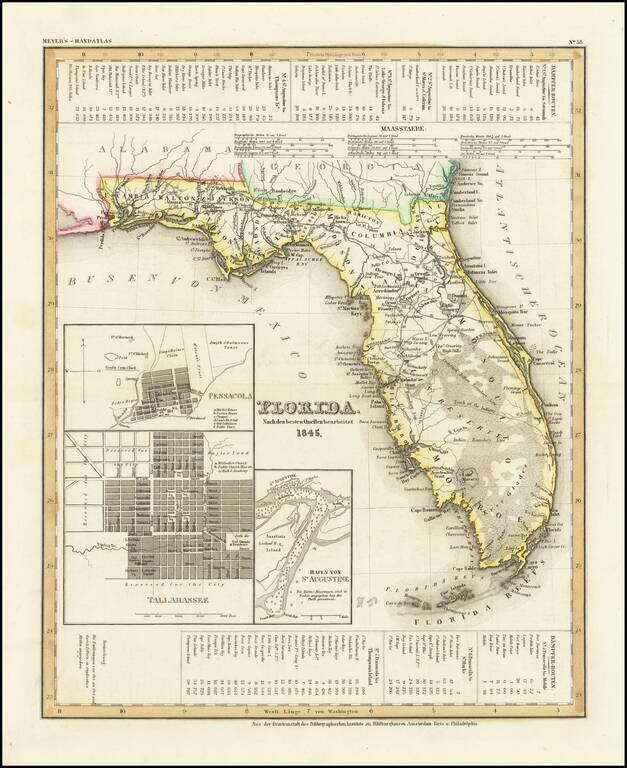
Scarce early map of Florida, published in the year was admitted to the Union.
Shows early roads, towns, rivers, lakes, islands and other features. Mosquito County extends from Lake George to Lake Macaco and only Monroe, Hillsboro and Dade Counties are shown in the southern 2/3rds of the state, with Dade appearing far northwest of its current position. Includes plans of Pensacola, Tallahassee and the Harbor at St. Augustine. Includes distance tables between a number of major and minor cities.
From one of the leading German map makers of the period.
Joseph Meyer (1796-1856) was a German publisher who released Meyers Konversations-Lexikon, a German-language encyclopedia in print from 1839 to 1984. Meyer was born in Gotha and educated as a merchant in Frankfurt, an important city in the book trade. He traveled in London in 1816 and was back in German in 1820, where he began to invest in textiles and railways. He opened his publishing operation, Bibliographisches Institut, in 1826. His publications each had a serial number, a new innovation at the time. He was best known for his atlases and the Meyers Universum (1833-1861), which featured steel-engravings of the world. The Universum stretched to 17 volumes in 12 languages and was subscribed to by 80,000 people all over Europe. Thanks to his publishing success, Meyer moved the Institut from Gotha to Hildburghausen in 1828. Meyer died in the latter city in 1856.
If you are a student, write to us in telegram: @antiquemaps and indicate what material you need and for what work you need a map in high detail. We are ready to provide material on special terms. For students only!

![[Wall Map] West-Indische Paskaert waer in de graden der breedde over weder zyden vande middelyn wassende so vergrooten dat die geproportioneert syn tegen hunne nevenstaende graden de lengde.](/map/small/60169.jpg)
