Map size in jpg-format: 3.13926MiB
Click to open in high resolution (open in new tab).
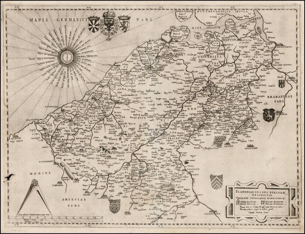
Nice example of Claudio Duchetti's map of northwestern Belgium and the southwestern part of the Netherlands.
Duchetti's map is based upon Jacobus Bossius's map of the same title, published in Venice in 1555, by Michaelis Tramezini. The Bossius's map is drawn from Gerard Mercator's 4-sheet map of Flanders, published in 1540.
The map extends from Calais (Caletum) in the west to Brussel (Bruxellae) in the east, and from Antwerp (Handouerpia) in the north to Lens and Valenciennes (Valentianae) in the south.
The map includes a key identifying the abbeys and priories for both men and women, with a key to their abbreviations listed in the strapwork title cartouche. A fine wind rose occupies the North Sea, and the map is further decorated with several coats of arms and a large pair of dividers atop the distance scale.
Unlike many of the maps of this time period, Duchetti's map was published only once. By contrast, the Bossius map was re-issued by Stopius (1559), Zenoi (1559), Camocio (1559), and Forlani (1567). The map is very rare on the market, with Tooley locating only 1 example not bound into a Lafreri Composite Atlas (8 examples in Atlases). We note no other reported examples of this map on the market or at auction in over 30 years (this copy was purchased at auction in 2013).
Claudio Duchetti was the nephew of Antoni Lafreri and a successor to his business. Lafreri and Duchetti published their works in Rome, one of the map-making capitals of Europe during the sixteenth century. Duchetti is one of a group of 16th Century Italian mapmakers often referred to as "Lafreri School," and named for the Roman mapmaker and publisher Antoni Lafreri. Lafreri assembled composite atlases of maps published by himself and other Italian mapmakers and added his title page to some examples. Lafreri maps are often among the earliest obtainable modern maps of various regions of the world. While most maps were separately issued, some were bound in composite atlases, which increased the prospects of their survival until modern times.
If you are a student, write to us in telegram: @antiquemaps and indicate what material you need and for what work you need a map in high detail. We are ready to provide material on special terms. For students only!


