Map size in jpg-format: 84.7733MiB
Click to open in high resolution (open in new tab).
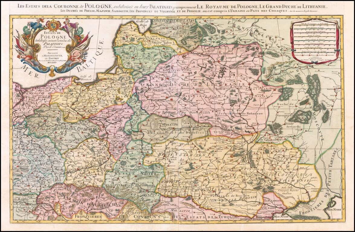
Nice example of the Pierre Mortier edition of this large format map of Poland, Lithuania, the Ukraine and part of Russia, first published by Hubert Jaillot in Paris, in 1679.
One of the largest atlas maps of the late 17th Century to focus on Poland, Lithuania and Ukraine.
Because of the size of the map, its accuracy and visual appeal, the map would have had a profound impact on European culture at the end of the 17th Century, as commercial success of the Jaillot and Covens & Mortier Atlases made this map one of the most widely viewed and easily accessible maps of Poland available to the public at the end of the 18th Century.
At the end of the 1670s, Alexis Hubert Jaillot began to create a set of 2 sheet maps of the regions of France and the World, which would first be issued in Atlas form circa 1680. Drawing primarily on the cartographic content created by Nicolas Sanson and Guillaume Sanson, Jaillot's atlas maps would become the largest format set of Atlas maps to be published in a commercial atlas in the 17th Century. Shortly after the initial publication, the maps would be copied by a number of mapmakers, including Pierre Mortier (and later Covens & Mortier) in Amsterdam, William Berry in London and Johann Hoffman in Nuremberg.
Both the Jaillot Atlas and the Mortier Atlas would become commercially successful and would become the forerunners to the works of other publishers, most notably Herman Moll and the Price-Senex atlases of the first part of the 18th Century, however none of these other ventures would achieve a similar level of success and widespread distribution.
Pierre, or Pieter, Mortier (1661-1711) was a Dutch engraver, son of a French refugee. He was born in Leiden. In 1690 he was granted a privilege to publish French maps in Dutch lands. In 1693 he released the first and accompanying volume of the Neptune Francois. The third followed in 1700. His son, Cornelis (1699-1783), would partner with Johannes Covens I, creating one of the most important map publishing companies of the eighteenth century.
If you are a student, write to us in telegram: @antiquemaps and indicate what material you need and for what work you need a map in high detail. We are ready to provide material on special terms. For students only!


![[Hand Drawn Prussian Military Encampment at Opole, Poland] Special Grund-Riss Des Kaeyserl Feldl Lagers bey Oppeln in Ober Schlesien](/map/small/59726.jpg)