Map size in jpg-format: 36.1047MiB
Click to open in high resolution (open in new tab).
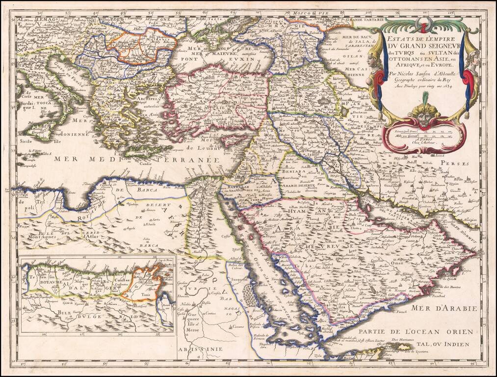
The Ottoman Empire by Nicolas Sanson.
Sanson's map shows the powerful Ottoman Empire of the mid-seventeenth century, extending from Italy to the Straits of Hormuz. There is excellent detail from Italy to the Caspian Sea and the Arabian Peninsula. The colored portions denote Ottoman possession, with an inset in inland Africa depicting Algeria.
In the upper right corner is a cartouche encasing the title. Two women in supposedly Ottoman headdress flank the two sides, while a male Ottoman head is at center, between the title and scale. The man, who may be the Sultan, looks out at the reader solemnly. As Brummett explains, this cartouche is not a martial call to defeat Ottomans, as previous cartouches of European maps of Ottoman territory were, but rather an acknowledgment of Ottoman power in a world of empires.
Nicholas Sanson (1600-1667) is considered the father of French cartography in its golden age from the mid-seventeenth century to the mid-eighteenth. Over the course of his career, he produced over 300 maps. His influence is shown particularly with this map, as it would be taken up and re-issued by William Berry and Hubert Jaillot, among others.
Nicholas Sanson (1600-1667) is considered the father of French cartography in its golden age from the mid-seventeenth century to the mid-eighteenth. Over the course of his career he produced over 300 maps; they are known for their clean style and extensive research. Sanson was largely responsible for beginning the shift of cartographic production and excellence from Amsterdam to Paris in the later-seventeenth century.
Sanson was born in Abbeville in Picardy. He made his first map at age twenty, a wall map of ancient Gaul. Upon moving to Paris, he gained the attention of Cardinal Richelieu, who made an introduction of Sanson to King Louis XIII. This led to Sanson's tutoring of the king and the granting of the title ingenieur-geographe du roi.
His success can be chalked up to his geographic and research skills, but also to his partnership with Pierre Mariette. Early in his career, Sanson worked primarily with the publisher Melchior Tavernier. Mariette purchased Tavernier’s business in 1644. Sanson worked with Mariette until 1657, when the latter died. Mariette’s son, also Pierre, helped to publish the Cartes générales de toutes les parties du monde (1658), Sanson' atlas and the first French world atlas.
If you are a student, write to us in telegram: @antiquemaps and indicate what material you need and for what work you need a map in high detail. We are ready to provide material on special terms. For students only!
![[Facsimile - 15th Century Portolan Sea Chart] Portolan des Iehuda ben Zara](/map/small/64285.jpg)