Map size in jpg-format: 76.2399MiB
Click to open in high resolution (open in new tab).
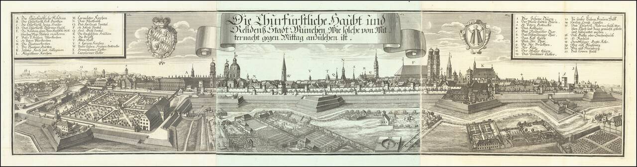
Very decorative and large panoramic view of Munich, published by Michael Wening.
The city is shown surrounded by a massive palisade, glacis, mote, and walls. Inside, large buildings, churches, gardens, etc. can be seen. Landmarks inside and outside the walls are described in two keys, one in the upper left (A-Z) and one in the upper right (1-21).
To the right of the title banner is the Münchner Wappen, or Munich Coat of Arms, which features a young monk, dressed in black, holding a book in his left hand. To the left of the title banner is the coat of arms of Bavaria as it was from 1623-1777.
Michael Wening (1645-1718) was born in Nuremberg in 1645 as the son of Schweinmetzger Balthasar Wening and his wife Katharina. He moved to Munich in 1669, after leaving his hometown the year before. In the 1670s he was working as an engraver, and by 1675 he was appointed court copperplate engraver. In 1680 he was a Knight Elector's Porter.
During the Turkish Wars, Wening made numerous engravings of battles for Elector Max Emanuel.
On November 12, 1692, he moved from Dachau through the country with a princely patent. By January, he had already mapped 131 locations. On November 2, 1701, the first volume of the Historico-topographica descriptio Bavariae (1701–1726) was completed with the Munich Rentamt. In this four-volume main work, are pictures of Bavarian cities, castles, and monasteries, arranged according to rent offices. In total, he made engravings of over 1000 places.
The texts were written by the Jesuit Ferdinand Schönwetter. Wening also created portraits and vedutas and engravings of the battles of Elector Max Emanuel in the fight against the Turks.
If you are a student, write to us in telegram: @antiquemaps and indicate what material you need and for what work you need a map in high detail. We are ready to provide material on special terms. For students only!


