Map size in jpg-format: 24.7108MiB
Click to open in high resolution (open in new tab).
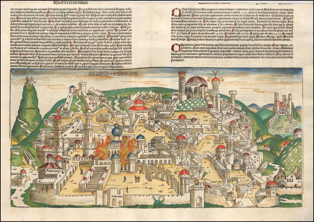
Gorgeous example of Hartmann Schedel's incunable view of Jerusalem from a German edition of Schedel's Liber Chronicum, perhaps the single most influential secular illustrated book of the 15th century and one of the landmark printed works of the 15th century.
Schedel's view of Jerusalem is one of the earliest obtainable views of the city, and realistically, the only large format 15th century illustrations available to collectors.
The Nuremberg Chronicle
Hartmann Schedel's Liber Chronicarum: Das Buch der Croniken und Geschichten (loosely translated as World Chronicle, but popularly referred to as the Nuremberg Chronicle) was the first secular book to include the style of lavish illustrations previously reserved for Bibles and other liturgical works. The work was intended as a history of the world, from Creation to 1493, with a final section devoted to the anticipated Last Days of the World.
This work is without question the most important illustrated secular work of the fifteenth century and its importance rivals the early printed editions of Ptolemy's Geographia and Bernard von Breydenbach's Perengrinatio in Terram Sanctam in terms of its importance in the development and dissemination of early illustrated books. Published in Nuremberg by Anton Koberger, the book was first printed in Latin and followed five months later by a German edition translated by George Alt. This work enjoyed immense commercial success. A reduced-size version of the book was published in 1497, in Augsburg, by Johann Schonsperger. The illustration for Venice is adapted from the larger illustration of Venice in Breydenbach's Peregrinatio, which was illustrated by Dutch artist Erhard Reuwich, who was working in Mainz in the 1480s.
While the majority of the illustrations in the book depict the various saints, royalty, nobility, and clergyman of the period, the work is perhaps best known for the large-format views of a number of the major European cities, including Rome, Venice, Paris, Vienna, Florence, Genoa, Saltzburg, Crakow, Breslau, Budapest, Prague, and major cities in the Middle East, including Jerusalem, Alexandria, and Constantinople. The work also included a magnificent double-page map of the world, a large map of Europe and several famous illustrations, including the "Dance of Death" and scenes from the Creation and the Last Judgement. While many of the double-page city views are less than accurate illustrations of the cities as they existed at the end of the fifteenth century, the illustrations are of great importance in the iconographic history of each of the cities depicted. Some of the double-page views were also apparently offered separately for sale, including some which had been colored prior to sale.
Schedel's world map is based upon Ptolemy, omitting Scandinavia, southern Africa, and the Far East, and depicting the Indian Ocean as landlocked. The depiction of the world is surrounded by the figures of Shem, Japhet and Ham, and the sons of Noah, who repopulated the Earth after the Flood. On the left, printed from a separate block, are pictures of various mythical creatures, based upon classical and early medieval travelers' accounts, including "a six-armed man, possibly based on a file of Hindu dancers so aligned that the front figure appears to have multiple arms; a six-fingered man, a centaur, a four-eyed man from a coastal tribe in Ethiopia; a dog-headed man from the Simien Mountains, a cyclops, one of those men whose heads grow beneath their shoulders, one of the crook-legged men who live in the desert and slide along instead of walking; a strange hermaphrodite, a man with one giant foot only (stated by Solinus to be used as a parasol but more likely an unfortunate sufferer from elephantiasis), a man with a huge underlip (doubtless seen in Africa), a man with waist-length hanging ears, and other frightening and fanciful creatures of a world beyond" (Stanford Ruderman catalog). The world map also includes a large island off the west coast of Africa, which may relate to the account of Martin Behaim's voyage to the region, which is referenced by Schedel in the text.
If you are a student, write to us in telegram: @antiquemaps and indicate what material you need and for what work you need a map in high detail. We are ready to provide material on special terms. For students only!


![[Early Montanus World Map in Volume Eight of the Plantin Polyglot Bible]](/map/small/53766.jpg)