Map size in jpg-format: 674511B
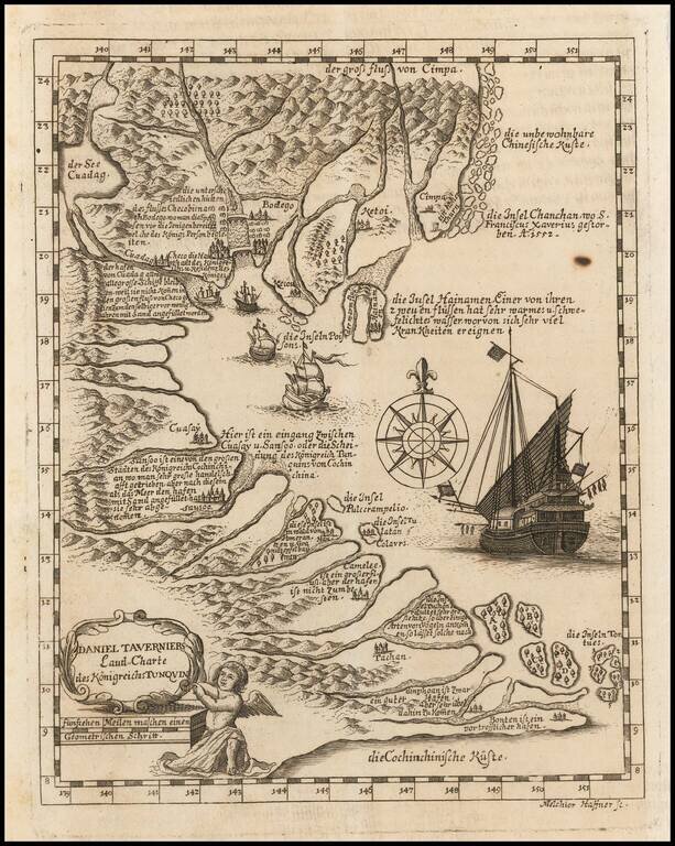
Rare German edition of Daniel Tavernier's map of Indo-China, engraved by Melchior Haffner.
The map covers the Gulf of Tonkin from Canton to Vietnam. The interior of the lands and islands are covered in sloping hills and orderly woods. Port cities mark the coastline with distinctive towers and buildings. Four small European ships, growing progressively larger the farther east they are, fill the inner Gulf, while a huge Asian vessel sits near the eastern border. It is next to a large compass rose. In the lower left corner is a frame cartouche surrounding the title and resting on the scale; the cartouche is held by a robed angel. Annotations pepper the map, describing borders, river systems, and famous sites, including the death of Francis Xavier, missionary to China.
The information for the map was based on the travels of Daniel Tavernier, the brother of Jean-Baptiste Tavernier, Huguenot gem merchant (1605-89). The latter was known for forging a European, particularly French, trade network with India and the Far East. Jean-Baptiste went on six voyages to the Indian Ocean. He is most famous for purchasing the 116-carat Tavernier Blue diamond in 1666. He sold the gem to Louis XIV in exchange for 120,000 livres and a noble title. Louis XIV cut the stone and set a 68 carat portion, the French Blue, in a hatpin. Louis XV again reset the stone in the Medal of the Order of the Golden Fleece. This was stolen in 1792 and appeared again in London three decades later. We know it today as the Hope Diamond.
Much less is known about Daniel. He accompanied his brother on his second voyage and settled in Batavia, where the Dutch East India Company had a large base. He gathered geographic knowledge of Tonkin based on numerous voyages to the region. Daniel's father and uncle were cartographers, which may have influenced his and his brother's travels and publications.
Melchior Haffner was a German engraver (1660-1704). He worked in Augsburg for most of his career, but was born and married in Ulm. His work appears mainly as inserts in books and includes portraits, frontispieces, and other paratext. He engraved the maps of China for Ferdinand Verbiest and the maps and engravings in J. B. Tavernier's Le Six Voyages de J. B. Tavernier (1676), where the Daniel Tavernier map first appeared.
This very rare version, with German text, comes from Delineatio Provinciarum Pannoniae et Imperii Turcici in Oriente Eine Grundrichtige Beschreibung deß ganzen Aufgangs... by Johann Christoph Wagner, published by Jacob Koppmayer in 1684.
If you are a student, write to us in telegram: @antiquemaps and indicate what material you need and for what work you need a map in high detail. We are ready to provide material on special terms. For students only!
![[Signed Political Satire Artwork] Vietnam ... Vietnam ... Vietnam ...](/map/small/68726.jpg)
![[Martin Behaim Globe / Book] Pars Globi terrestris Ao. 1492 a Martino Behaim Equite Lusitano Norimbergae confecti Delineavit Christoph. Theoph de Murr 1778 (bound with:) Diplomatische Geschichte des Portugesischen berühmten Ritters Martin Behaims](/map/small/68828.jpg)
![Il Disegno Della Terza Parte Dell' Asia [Gastaldi's Wall Map of SE Asia with extra panels!]](/map/small/30554hbp.jpg)