Map size in jpg-format: 8.36691MiB
Click to open in high resolution (open in new tab).

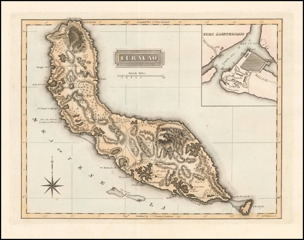
With Gallows Shown in Fort Amsterdam!
Scarce map of Curacao with a large inset of Fort Amsterdam by Fielding Lucas Jr., which appeared in his General Atlas, as well as his A New General Atlas of the West India Islands.
Lucas's map is the first detailed commercial map of Curacao published in America. The map depicts the roads, towns and interior topographic details of the island, including fresh water areas, plantations, wells and "mounts."
The inset map provides a fine account of the Fort and anchorage, along with two short wharves, one on either side of the bay. Even the location of the Gallows is shown.
The map is quite scarce on the market.
Fielding Lucas, Jr. (1781-1854) was a prominent American cartographer, engraver, artist, and public figure during the first half of the 19th century.
Lucas was born in Fredericksburg, Virginia and moved to Philadelphia as a teenager, before settling in Baltimore. There he launched a successful cartographic career. Lucas's first atlas was announced in early- to mid-1812, with production taking place between September 1812 and December of 1813, by which point the engravings were complete. Bound copies of the atlas -- A new and elegant general atlas: Containing maps of each of the United States -- were available early in the next year, beating Carey to market by about two months. Lucas later published A General Atlas Containing Distinct Maps Of all the known Countries in the World in the early 1820s.
If you are a student, write to us in telegram: @antiquemaps and indicate what material you need and for what work you need a map in high detail. We are ready to provide material on special terms. For students only!
![Cuba Insula [with] Hispaniola Insula [with] Insula Jamaica [with] Ins. S. Ioannis [with] I.S. Margareta Cum Confiniis](/map/small/70194.jpg)